Approximate Location Map
Large Map »
Latitude: 56.9 / 56°54'0"N
Longitude: -2.4502 / 2°27'0"W
OS Eastings: 372678
OS Northings: 778834
OS Grid: NO726788
Mapcode National: GBR X5.WX4F
Mapcode Global: WH8QL.BTHQ
Plus Code: 9C8VWG2X+2W
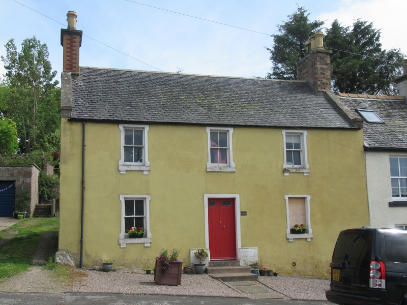
Entry Name: Chestnut House, High Street, Auchenblae
Listing Name: Chestnut House High Street Auchenblae
Listing Date: 25 November 1980
Category: C
Source: Historic Scotland
Source ID: 343203
Historic Scotland Designation Reference: LB10719
Building Class: Cultural
ID on this website: 200343203
Location: Fordoun
County: Aberdeenshire
Electoral Ward: Mearns
Parish: Fordoun
Traditional County: Kincardineshire
Tagged with: House
Earlier 19th century, altered later. 2-storey, stuccoed and lined out as ashlar. 3-window front with central boarded door, small fenestration with 4-pane sashes. All windows in plain architraves on corbelled cills. Slated roof. Straight skews with end blocks.
External links are from the relevant listing authority and, where applicable, Wikidata. Wikidata IDs may be related buildings as well as this specific building. If you want to add or update a link, you will need to do so by editing the Wikidata entry.


Other nearby listed buildings
