Approximate Location Map
Large Map »
Latitude: 56.3177 / 56°19'3"N
Longitude: -5.5828 / 5°34'58"W
OS Eastings: 178532
OS Northings: 719693
OS Grid: NM785196
Mapcode National: GBR DDL0.PL1
Mapcode Global: WH0GX.6GSL
Plus Code: 9C8P8C98+3V
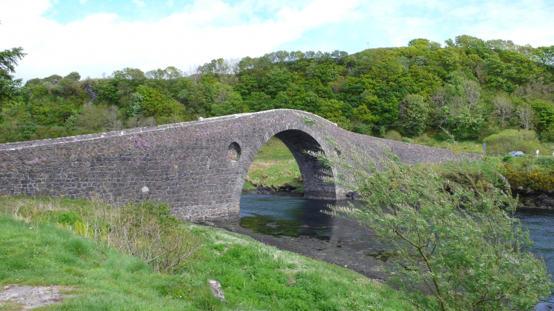
Entry Name: Clachan Bridge, Seil
Listing Name: Clachan Bridge, the Atlantic Bridge Sound of Seil
Listing Date: 20 July 1971
Category: A
Source: Historic Scotland
Source ID: 344438
Historic Scotland Designation Reference: LB11834
Building Class: Cultural
Also known as: Bridge over the Atlantic
ID on this website: 200344438
Location: Kilninver and Kilmelfort
County: Argyll and Bute
Electoral Ward: Oban North and Lorn
Parish: Kilninver And Kilmelfort
Tagged with: Arch bridge Road bridge Stone bridge
1792. Large segmental arch. Hump-backed. Random rubble. Rough coping. Blank oculi in spandrels. Narrow road.
Called 'the first bridge over the Atlantic'. Built high to allow passage of ships.
External links are from the relevant listing authority and, where applicable, Wikidata. Wikidata IDs may be related buildings as well as this specific building. If you want to add or update a link, you will need to do so by editing the Wikidata entry.


Other nearby listed buildings
