Approximate Location Map
Large Map »
Latitude: 55.9982 / 55°59'53"N
Longitude: -2.6219 / 2°37'18"W
OS Eastings: 361307
OS Northings: 678536
OS Grid: NT613785
Mapcode National: GBR 2Y.V4WZ
Mapcode Global: WH8VY.PHNK
Plus Code: 9C7VX9XH+76
Entry Name: Tyninghame Bridge
Listing Name: Tyninghame Bridge
Listing Date: 17 May 1989
Category: B
Source: Historic Scotland
Source ID: 347965
Historic Scotland Designation Reference: LB14583
Building Class: Cultural
Also known as: Tyne Bridge
ID on this website: 200347965
Location: Whitekirk and Tyninghame
County: East Lothian
Electoral Ward: Dunbar and East Linton
Parish: Whitekirk And Tyninghame
Tagged with: Road bridge
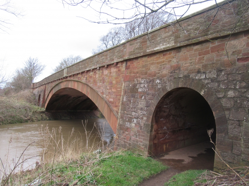
Blyth and Blyth, 1931. Low segmentally arched bridge with
flanking semi-circular overflow arches on banks. Pink
sandstone, squared and snecked for main bridge; stugged
voussoir to main span with hoodmould. Corbelled string course
below parapet with chamfered coping. Buttresses between main
and side arches.
Original bridge built here by Andrew Meikle, 1778,
probably the millwright from East Linton.
External links are from the relevant listing authority and, where applicable, Wikidata. Wikidata IDs may be related buildings as well as this specific building. If you want to add or update a link, you will need to do so by editing the Wikidata entry.


Other nearby listed buildings
