Approximate Location Map
Large Map »
Latitude: 55.8933 / 55°53'35"N
Longitude: -3.069 / 3°4'8"W
OS Eastings: 333240
OS Northings: 667200
OS Grid: NT332672
Mapcode National: GBR 7009.C8
Mapcode Global: WH6T1.T4RG
Plus Code: 9C7RVWVJ+89
Entry Name: The Old Meal Market Inn, 2-4 St Andrew Street, Dalkeith
Listing Name: 2 and 4 St Andrew Street, the Old Mealmarket Inn
Listing Date: 22 June 1971
Category: C
Source: Historic Scotland
Source ID: 360414
Historic Scotland Designation Reference: LB24465
Building Class: Cultural
ID on this website: 200360414
Location: Dalkeith
County: Midlothian
Town: Dalkeith
Electoral Ward: Dalkeith
Traditional County: Midlothian
Tagged with: Pub
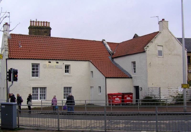
Late 18th century. Irregular group of 2-storey rectangular-plan buildings (formed into single property, with 2 gabled ranges facing W up South Street and gabled jamb forming L-plan to E. Harled. Raised painted margins.
W (ST ANDREW STREET) ELEVATION: lower left gable with door to right and 3 irregularly disposed windows, 2 at 1st floor. Right gable angled slightly to S; 3 irregularly disposed windows, 1 to left at 1st floor.
S AND W (SOUTH STREET) RE-ENTRANT ELEVATIONS: 2-bay S elevation with regularly disposed fenestration, broad window to left at ground, small window to right at 1st floor. Lean-to porch (in place of former forestair) with cat-slide roof running S in re-entrant angle; door to left of W face, window above and to right. Door and window above on W re-entrant elevation. Window to left in S-facing gablehead of jamb.
E ELEVATION: window to right at 1st floor, intercepted by transverse cartshed range running E.
Variety of small-pane glazing patterns in replacement sash and case windows. Coped skews; skew to main roof to E. Gablehead stacks. Modern pantiles.
The Old Mealmarket Inn was established in 1874; the building is marked as an Inn on the OS Map 1892-93. Various alterations to the openings of the building have been undertaken. The adjoining earlier 19th century 2-storey rubble arcaded former cartshed range (previously listed as Old Meal Market, Newmills Road), which was marked as a smithy on the OS Map 1852-53, has recently been severely modernised as part of the adjoining supermarket complex to the right. 2 red sandstone rubble gatepiers from former entrance have been retained in isolation, in modern landscaping.
External links are from the relevant listing authority and, where applicable, Wikidata. Wikidata IDs may be related buildings as well as this specific building. If you want to add or update a link, you will need to do so by editing the Wikidata entry.


Other nearby listed buildings
