Approximate Location Map
Large Map »
Latitude: 56.0049 / 56°0'17"N
Longitude: -2.5124 / 2°30'44"W
OS Eastings: 368142
OS Northings: 679224
OS Grid: NT681792
Mapcode National: GBR ND4V.CQ8
Mapcode Global: WH8W0.CBVF
Plus Code: 9C8V2F3Q+X2
Entry Name: Old Harbour, Dunbar
Listing Name: Old Harbour, Quays and Piers (Cromwell Harbour)
Listing Date: 5 February 1971
Category: B
Source: Historic Scotland
Source ID: 360927
Historic Scotland Designation Reference: LB24839
Building Class: Cultural
ID on this website: 200360927
Location: Dunbar
County: East Lothian
Town: Dunbar
Electoral Ward: Dunbar and East Linton
Tagged with: Harbour
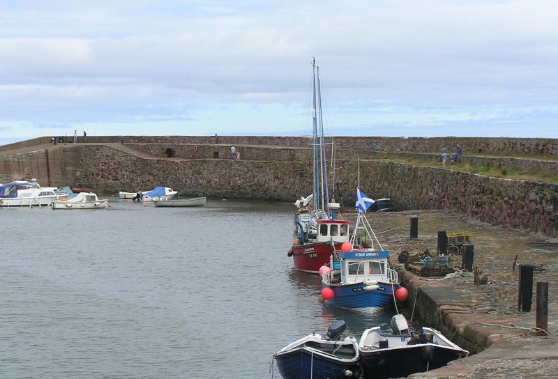
Earliest-mid 17th century; major works 1717. Harbour 565 feet
retaining walls to E pier as principal feature, sheltering
inner basin to S and larger to N. W side stepped by wharves.
Return pier at NE by entrance.
E PIER: marked variation in masonry form, partially resulting
from repairs; outer E wall with large area of vertically-set
stone. W face of sandstone slabs and blocks, set obliquely
and vertically.
Flight of steps at angle of pier leading to inner basin
severly weathered.
Rubble parapet wall to E side of walkway, walk divides at
widest point to higher and lower levels; flagstone edging.
Pierhead rebuilt 1879, extreme N.
RETURN PIER: probably 1717, running on NW angle, 170 feet
long, ending at harbour entrance. Original masonry to SW with
squared and coursed blocks parapet secured with ironbolts.
Short return wall at S of SW end. Boom pier 1888, tail-piece
of returned pier, 30 feet long; large masonry and concrete.
QUAYS TO W: more regularly coursed sandstone rubble blocks;
chase groove pair to NE opposite boom pier. Coal wharf, 1761,
at S corner of inner basin, sloping to harbour floor; large
cobbles, setts and bordering slabs.
RAMP E OF E PIER PARAPET: large setts, bordering sandstone
slabs, some bearing inscriptions.
Pawls remaining at intervals.
Cromwell allegedly gave $300 for harbour construction
(Groome). Dry dock formerly in quay S of Victoria Street post
1785; filled in by mid 19th century.
External links are from the relevant listing authority and, where applicable, Wikidata. Wikidata IDs may be related buildings as well as this specific building. If you want to add or update a link, you will need to do so by editing the Wikidata entry.


Other nearby listed buildings
