Approximate Location Map
Large Map »
Latitude: 55.0694 / 55°4'9"N
Longitude: -3.616 / 3°36'57"W
OS Eastings: 296907
OS Northings: 576180
OS Grid: NX969761
Mapcode National: GBR 395T.YL
Mapcode Global: WH5WJ.FVB4
Plus Code: 9C7R399M+PJ
Entry Name: 16 Buccleuch Street, Dumfries
Listing Name: 16 Buccleuch Street
Listing Date: 6 March 1981
Category: C
Source: Historic Scotland
Source ID: 362596
Historic Scotland Designation Reference: LB26105
Building Class: Cultural
ID on this website: 200362596
Location: Dumfries
County: Dumfries and Galloway
Town: Dumfries
Electoral Ward: Nith
Traditional County: Dumfriesshire
Tagged with: Architectural structure
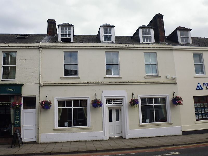
Mid 19th century. 2 storeys, 3 bays. Droved red ashlar
with polished dressings and ground floor architraves. Central
recessed door with fanlight; enlarged windows in outer
bays; string between floors; 1st floor windows plate
glass sashes. Cornice; blocking course; 2 small-paned
piended square dormers; straight skews; end stacks; slate
roof.
External links are from the relevant listing authority and, where applicable, Wikidata. Wikidata IDs may be related buildings as well as this specific building. If you want to add or update a link, you will need to do so by editing the Wikidata entry.


Other nearby listed buildings
