Approximate Location Map
Large Map »
Latitude: 55.9852 / 55°59'6"N
Longitude: -2.6545 / 2°39'16"W
OS Eastings: 359261
OS Northings: 677111
OS Grid: NT592771
Mapcode National: GBR 2X.VX5Z
Mapcode Global: WH8VY.6T6J
Plus Code: 9C7VX8PW+35
Entry Name: Old Tyne Bridge, East Linton
Listing Name: Bridge End, Old Bridge
Listing Date: 5 February 1971
Category: A
Source: Historic Scotland
Source ID: 363288
Historic Scotland Designation Reference: LB26632
Building Class: Cultural
Also known as: East Linton Bridge
Old Tyne Bridge
East Linton, Old Tyne Bridge
ID on this website: 200363288
Location: East Linton
County: East Lothian
Town: East Linton
Electoral Ward: Dunbar and East Linton
Traditional County: East Lothian
Tagged with: Bridge Road bridge
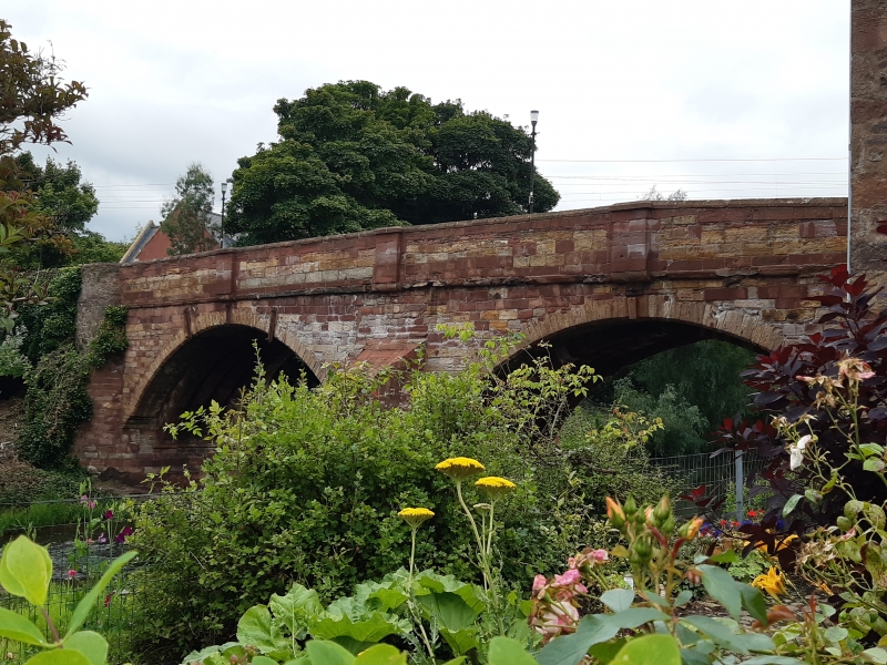
Mid-late 16th century, with later alterations and repairs
dated 1763 and 1934. 2 arched, ribbed bridge over River
Tyne, (carrying old post road), aligned NW and SE 98 ft
length, 31 ft 6 ins above river bed squared and coursed
red and yellow sandstone.
Central pier with stepped cutwater of droved masonry;
upper cut water 6 ft high. 2 segmental arches tied with
rods and straps, with yellow chamfered voussoirs. 4
chamfered ribs to soffits, flanked by 3 ft wide unribbed
strips with keystone dated 1763. Impost moulding to
abutments, discontinued where widened at SE.
Abutments splayed onto banks. Parapet of gablet coped
coursed sandstone; string course and 3 red sandstone dies.
Repair before parliament in 1625, 1639 and 1661. Keystone date
1763 presumably refers to widening. Concrete laid on extrados
of arches circa 1884 parapets raised circa 1895. Further repairs
indicated by incised date 1934. Arrangement of chamfered ribs
and impost moulding at springing-line similar to Abbey Bridge, near
Haddington. A stone bridge existed here in 1547, crossed by
English infantry and destroyed to delay their retreat.
Probably rebuilt circa 1560.
Formerly a ford was situated about 100 yds upstream. A
shallow weir runs NE from the central pier. Bridge adjoins
No 5 Bridge End to NW.
External links are from the relevant listing authority and, where applicable, Wikidata. Wikidata IDs may be related buildings as well as this specific building. If you want to add or update a link, you will need to do so by editing the Wikidata entry.


Other nearby listed buildings
