Approximate Location Map
Large Map »
Latitude: 55.9521 / 55°57'7"N
Longitude: -3.1764 / 3°10'35"W
OS Eastings: 326636
OS Northings: 673858
OS Grid: NT266738
Mapcode National: GBR 8SF.2T
Mapcode Global: WH6SM.5NPD
Plus Code: 9C7RXR2F+VC
Entry Name: Well, Queensberry House, 64 Canongate, Edinburgh
Listing Name: Canongate, Well at Queensberry House
Listing Date: 14 December 1970
Category: B
Source: Historic Scotland
Source ID: 365249
Historic Scotland Designation Reference: LB27895
Building Class: Cultural
ID on this website: 200365249
Location: Edinburgh
County: Edinburgh
Town: Edinburgh
Electoral Ward: City Centre
Traditional County: Midlothian
Tagged with: Well
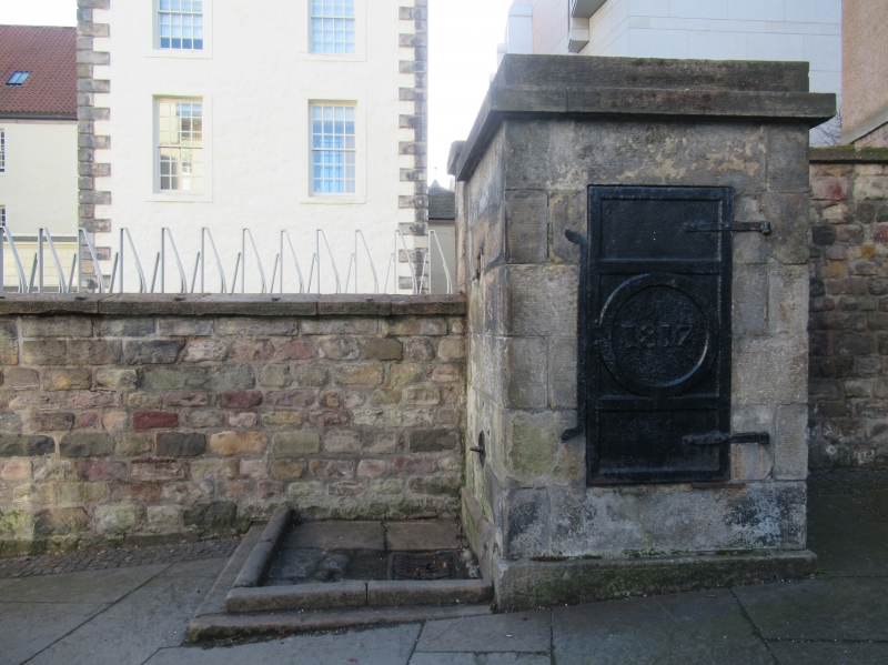
Dated 1817. Square-plan, flat-roofed ashlar wellhouse on sloping ground adjoining boundary wall to Queensberry House. Base course and block cornice. Cast-iron door to N elevation with raised date panel. Cast-iron tap to E with square drainage trough below.
Encased in a square ashlar built housing, this well is a good, rare survival of its type. Prominently located beside Queensberry House (see separate listing) the well provides contextual and historic integrity to the surrounding area, as well as adding streetscape interest. A run of wells was originally situated at regular intervals from the bottom of the Canongate to the top of the High Street, of which only three now remain. The wells provided the residents of the Old Town with a significant leap forward in the levels of sanitation in the area and, as great numbers would gather there, they played a significant role in the social and commercial life of the City during the 19th century.
The historic and architectural value of Edinburgh's Canongate area as a whole cannot be overstated. Embodying a spirit of permanence while constantly evolving, its buildings reflect nearly 1000 years of political, religious and civic development in Scotland. The Canons of Holyrood Abbey were given leave by King David I to found the burgh of Canongate in 1140. Either side of the street (a volcanic ridge) was divided into long, narrow strips of land or 'tofts'. By the end of the 15th century all the tofts were occupied, some subdivided into 'forelands' and 'backlands' under different ownership. Fuedal superiority over Canongate ceased after 1560. The following century was a period of wide-scale rebuilding and it was during this time that most of the areas' mansions and fine townhouses were constructed, usually towards the back of the tofts, away from the squalor of the main street. The 17th century also saw the amalgamation of the narrow plots and their redevelopment as courtyards surrounded by tenements. The burgh was formally incorporated into the City in 1856. Throughout the 19th Century the Canongate's prosperity declined as large sections of the nobility and middle classes moved out of the area in favour of the grandeur and improved facilities of Edinburgh's New Town, a short distance to the North. The Improvement Act of 1867 made efforts to address this, responding early on with large-scale slum clearance and redevelopment of entire street frontages. A further Improvement Act (1893) was in part a reaction to this 'maximum intervention', responding with a programme of relatively small-scale changes within the existing street pattern. This latter approach was more consistent with Patrick Geddes' concept of 'conservative surgery'. Geddes was a renowned intellectual who lived in the Old Town and was a pioneer of the modern conservation movement in Scotland which gathered momentum throughout the 20th century. Extensive rebuilding and infilling of sections of the Canongate's many tenements took place, most notably by city architects, E J McRae and Robert Hurd (mid 20th century) with some early frontages retained and others rebuilt in replica.
List description updated at resurvey (2007/08).
External links are from the relevant listing authority and, where applicable, Wikidata. Wikidata IDs may be related buildings as well as this specific building. If you want to add or update a link, you will need to do so by editing the Wikidata entry.


Other nearby listed buildings
