Approximate Location Map
Large Map »
Latitude: 55.9357 / 55°56'8"N
Longitude: -3.1735 / 3°10'24"W
OS Eastings: 326785
OS Northings: 672027
OS Grid: NT267720
Mapcode National: GBR 8SM.NP
Mapcode Global: WH6ST.721F
Plus Code: 9C7RWRPG+7H
Entry Name: 21-21B Blacket Place, Edinburgh
Listing Name: 21 and 21B Blacket Place, Including Boundary Walls
Listing Date: 14 December 1970
Category: B
Source: Historic Scotland
Source ID: 366054
Historic Scotland Designation Reference: LB28305
Building Class: Cultural
Also known as: Edinburgh, 21-21b Blacket Place
ID on this website: 200366054
Location: Edinburgh
County: Edinburgh
Town: Edinburgh
Electoral Ward: Southside/Newington
Traditional County: Midlothian
Tagged with: Architectural structure
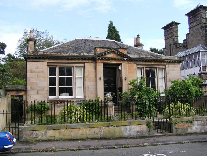
Mid - later 19th century. Single storey symmetrical 3-bay square-plan classical villa with basement. Polished sandstone ashlar; stugged rubble to sides and rear. Base course; eaves course; modillioned cornice; blocking course; architraved windows.
W (ENTRANCE) ELEVATION: steps up to entrance; advanced doorpiece with modillioned pediment breaking eaves; architraved doorway; 6-panel timber door with plate glass fanlight; tripartite windows to flanking bays; corniced gateway leading to rear to N; to S, gate leads down steps to 2-storey single bay wing at basement level with timber panelled door to No 21B to ground and a single window to 1st floor above.
6-pane timber sash and case windows flanked on either side by 3-pane sash and case windows to main block; 4-pane timber sash and case window to wing. Grey slate piended roof with central cupola; corniced and shouldered wallhead stacks with octagonal cans; coped stack to rear with octagonal cans.
INTERIOR: not seen 1996.
BOUNDARY WALLS: low coped boundary walls to street with piers flanking; coped mutual boundary walls with Nos 19 and 23.
Dr Benjamin Bell of Hunthill, an eminent Edinburgh surgeon and farmer, speculated on the potential for development in the lands of Newington. In 1806, aware of the demand for countrified dwellings near the city, he advertised his intention to sell 58 plots of land within his 8.5 acres. On his death in the same year his son George Bell, also a surgeon, inherited the land and, in 1825, commissioned James Gillespie Graham to design a plan for new streets within the grounds of Newington House, bounded by the back garden walls of Minto Street, Salisbury Road, East Mayfield and Dalkeith Road. Feus were offered for sale and Blacket Place began to take shape, the houses possibly being built speculatively by one builder or building company. Security was an important feature of the development, with Gothic gates, the octagonal piers of which survive, locked at night and single storey lodges at the entrances from Minto Street and Dalkeith Road.
External links are from the relevant listing authority and, where applicable, Wikidata. Wikidata IDs may be related buildings as well as this specific building. If you want to add or update a link, you will need to do so by editing the Wikidata entry.


Other nearby listed buildings
