Approximate Location Map
Large Map »
Latitude: 55.9505 / 55°57'1"N
Longitude: -3.1868 / 3°11'12"W
OS Eastings: 325984
OS Northings: 673692
OS Grid: NT259736
Mapcode National: GBR 8PG.ZD
Mapcode Global: WH6SM.0PRL
Plus Code: 9C7RXR27+67
Entry Name: 127-129 High Street, Edinburgh
Listing Name: 127 and 129 High Street
Listing Date: 11 January 1989
Category: B
Source: Historic Scotland
Source ID: 368226
Historic Scotland Designation Reference: LB29043
Building Class: Cultural
ID on this website: 200368226
Location: Edinburgh
County: Edinburgh
Town: Edinburgh
Electoral Ward: City Centre
Traditional County: Midlothian
Tagged with: Tenement
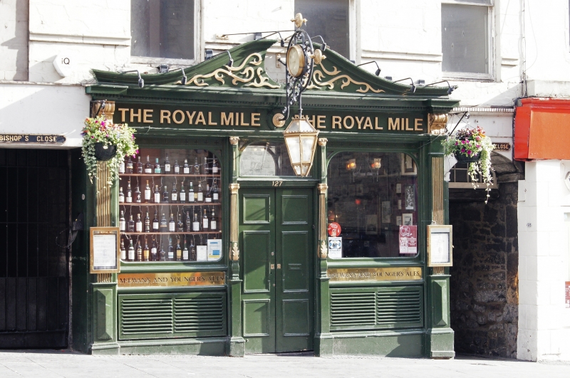
Thomas Bonnar, 1813, incorporating earlier fabric to rear. 2-storey 3-bay public house in eastern part of 5-storey 7-bay tenement reduced in height circa 1970 (see Notes). Early 20th century timber 3-bay pub front (see Notes). Segmental-arched pend to right (North Gray's Close) beneath dentilled cornice; pend to left (Bishop's Close). Painted ashlar 1st floor.
S (HIGH STREET) ELEVATION: 2-leaf timber storm door with segmental-arched fanlight; flanking segmental-arched windows; timber fluted pilasters dividing bays; consoled and dentilled cornice above; swept broken pediment; 3 1st floor windows with cills lowered below cill course.
E (NORTH GRAY'S CLOSE) ELEVATION: random rubble-built; ashlar margins to single and bipartite windows.
W ELEVATION: to Bishop's Close; some early stonework and blocked doorway (possibly 17th century); off-centre segmental archway in wall closing Bishop's Close; pend through to rear of tenement to W.
Plate glass timber sash and case 1st floor windows; plate glass to public house. Modern roof behind continuous timber fascia.
INTERIOR: reproduction pub interior.
In use as public house (the Royal Mile). A restored stone lintel in the pend of North Gray's Close reads 'BLISST BE YE LORD FOR ALL HIS GIFTS 1578', has an armorial and the intials 'VN' 'HM'. This stone came from the original Bishop's Land - the house of Archbishop Spottiswood (d.1639) - which fronted the High Street (see Grant p208). The site itself still conforms to the long, narrow burgage plot form of the old mediaeval town plan, as can be seen from the maps cited above. Bishop's Land is also associated with (among many others) Thomas Sydserf or Saintserff (1581-1663), successively of bishop of Brechin, Galloway and Orkney. It was later the birthplace in 1742 of Henry Dundas, Viscount Melville, whose statue tops the column in St Andrew Square. The aforementioned lintel is inscribed 'Restored 1813' and was re-instated when Thomas Bonnar's 7-bay 5-storey pedimented tenement was constructed on the site. Photographs in the NMRS collection (ED/5048, ED/5049) dated 1970 show this, and the early 18th century 5-storey and attic 4-bay tenement to the east, still intact prior to demolition circa 1970 which left only the ground and first floors in this row. The present pub frontage does not appear in the 1970 photos and has clearly been re-located from elsewhere. Notes in the Edinburgh Old Town Study Record suggest the addition of the frontage to be post-1986.
External links are from the relevant listing authority and, where applicable, Wikidata. Wikidata IDs may be related buildings as well as this specific building. If you want to add or update a link, you will need to do so by editing the Wikidata entry.


Other nearby listed buildings
