Approximate Location Map
Large Map »
Latitude: 55.9463 / 55°56'46"N
Longitude: -3.2054 / 3°12'19"W
OS Eastings: 324818
OS Northings: 673241
OS Grid: NT248732
Mapcode National: GBR 8LH.6X
Mapcode Global: WH6SL.QSVV
Plus Code: 9C7RWQWV+GV
Entry Name: 101 Lothian Road, Edinburgh
Listing Name: 95-103 (Odd Nos) Lothian Road
Listing Date: 29 March 2001
Category: C
Source: Historic Scotland
Source ID: 368744
Historic Scotland Designation Reference: LB29268
Building Class: Cultural
ID on this website: 200368744
Location: Edinburgh
County: Edinburgh
Town: Edinburgh
Electoral Ward: City Centre
Traditional County: Midlothian
Tagged with: Architectural structure
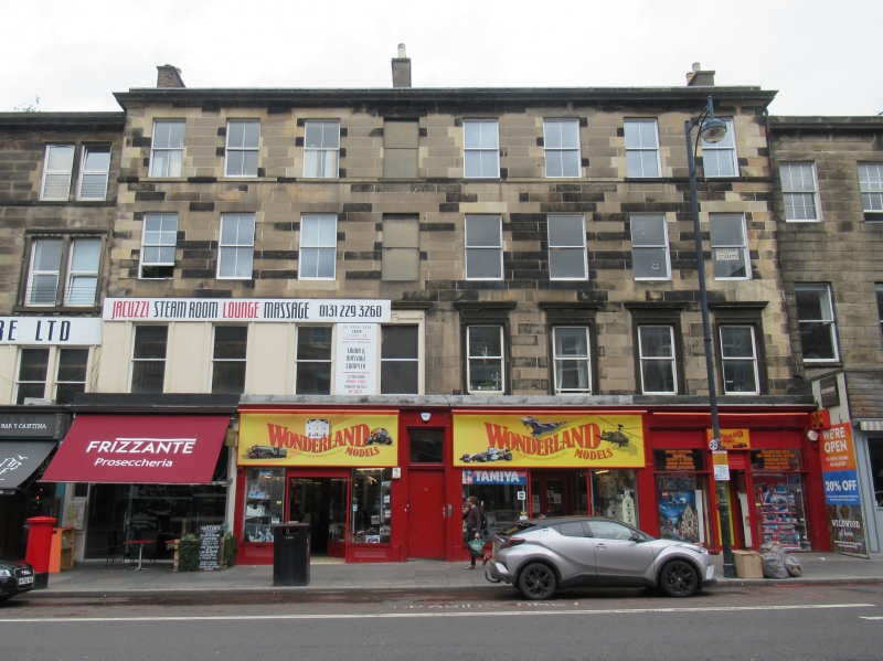
David MacGibbon, 1864. 4-storey 8-bay plain classical terraced tenement (slightly taller than its neighbours) with later shops at ground floor. Coursed ashlar (3 outer left bays at 1st floor painted black). Continuous cornice above shops; cill course at 3rd floor level; moulded eaves cornice. Modern shop fronts. Regularly fenestrated; corniced architraves to 1st floor windows.
Plate glass in timber sash and case windows. Corniced rendered ridge stacks with circular cans.
Nos 71-103 Lothian Road were designed by David MacGibbon (Thomas Hamilton's successor as advisor to the Merchant Company) to complete Burn's plain palace block, echoing his design for Nos 125-165 Lothian Road (formerly known as Downie Place), and forming an impressive piece of urban design in an important situation. On Kincaid's 1784 map Lothian Road is marked as 'New Road' and flanked by fields. A plan similar to what was built for this area, with a square to be known as Orchardfield Square where the Usher Hall is, marked 'This square is not built but is intended,' is on Ainslie's 1804 map. Wood's 1820 plan shows the area more or less as eventually built. The Merchant Company adopted William Burn's plan for the Grindlay's Orchardfield estate in 1820. The 1877 OS map shows this block (Lothian Road, Grindlay Street, Bread Street) complete.
External links are from the relevant listing authority and, where applicable, Wikidata. Wikidata IDs may be related buildings as well as this specific building. If you want to add or update a link, you will need to do so by editing the Wikidata entry.


Other nearby listed buildings
