Latitude: 57.6103 / 57°36'37"N
Longitude: -3.6121 / 3°36'43"W
OS Eastings: 303778
OS Northings: 858956
OS Grid: NJ037589
Mapcode National: GBR K8GL.S51
Mapcode Global: WH5H4.HZ57
Plus Code: 9C9RJ96Q+45
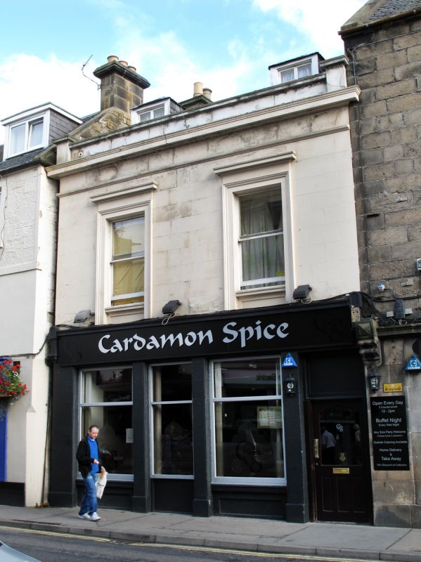
Entry Name: 66 High Street, Forres
Listing Name: 64, 66 High Street
Listing Date: 30 March 1983
Category: C
Source: Historic Scotland
Source ID: 372982
Historic Scotland Designation Reference: LB31682
Building Class: Cultural
ID on this website: 200372982
Location: Forres
County: Moray
Town: Forres
Electoral Ward: Forres
Traditional County: Morayshire
Tagged with: House
1830-40. 2 storeys and attic, 2 bays; late 19th century shop
with centre door and 2 windows, and flat arched pend in
ground floor. Painted ashlar to 1st floor with polished
ashlar margins. Architraves, aprons and cornices to 1st floor
windows; string course above, cornice and low parapet. 2
original piended dormers; 2-pane glazing. Slate roof.
6-bay wing to rear (No 64A and 64b) rubble, with tooled ashlar dressings.
Former Item 67 (1983 Revised List)
External links are from the relevant listing authority and, where applicable, Wikidata. Wikidata IDs may be related buildings as well as this specific building. If you want to add or update a link, you will need to do so by editing the Wikidata entry.


Other nearby listed buildings