Approximate Location Map
Large Map »
Latitude: 55.9557 / 55°57'20"N
Longitude: -2.7759 / 2°46'33"W
OS Eastings: 351650
OS Northings: 673898
OS Grid: NT516738
Mapcode National: GBR 2S.XSBD
Mapcode Global: WH7TY.BKDN
Plus Code: 9C7VX64F+7J
Entry Name: Building To The Rear Of 87 High Street
Listing Name: Kilpair Street, Warehouse to Rear of 87 High Street
Listing Date: 5 December 1977
Category: C
Source: Historic Scotland
Source ID: 378570
Historic Scotland Designation Reference: LB34332
Building Class: Cultural
ID on this website: 200378570
Location: Haddington
County: East Lothian
Town: Haddington
Electoral Ward: Haddington and Lammermuir
Traditional County: East Lothian
Tagged with: Architectural structure
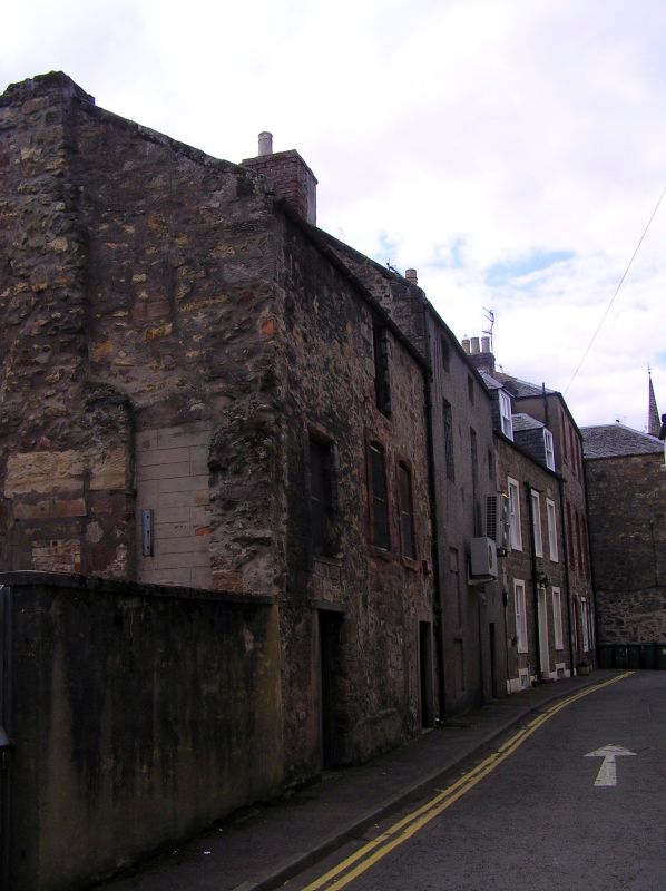
18th century with possible earlier fabric and later alterations. 3-storey and irregular 3-bay, rectangular-plan warehouse building with irregular fenestration pattern sited to the rear of Market Street to the heart of the town. Rubble stonework with raised margined red dressings to first floor windows, rough quoins to others, and smoother cement margins to ground. Entrance doors to outer bays with blocked former entrance to centre. Projecting rubble chimney breast and remnants of demolished neighbouring building to E gable.
Multi-pane timber windows to upper floors. Pitched roof. Cast-iron rainwater goods. Conjoined brick stack to W.
This building is a good example of an 18th century former warehouse. It has later alterations and is sited at the rear of Market Street to the heart of the historic burgh of Haddington. The building makes a strong contribution to the streetscape of the back lands of the town and evidences early fabric with its irregular window pattern rubble stone construction.
The building forms part of an area of 18th century buildings around Market Street, Brown Street and Kilpair Street, where buildings are tightly packed with narrow streets and clearly evidence their age. The building itself and general area are evident on early maps of the town where they would have been at the core of the trading centre of the burgh. The Burgh Survey suggests that Kilpair Street may date as far back as 1660 and so it is possible that this building may have evolved from that date. The 1853 town plan shows an external forestair to the East of the main elevation.
The current use of the building is not known (2013) but assumed to be used as storage. Previously listed as Warehouse, Kilpair Street at Rear of 86,87 High Street.
List description and statutory address updated 2013.
External links are from the relevant listing authority and, where applicable, Wikidata. Wikidata IDs may be related buildings as well as this specific building. If you want to add or update a link, you will need to do so by editing the Wikidata entry.


Other nearby listed buildings
