Approximate Location Map
Large Map »
Latitude: 58.9843 / 58°59'3"N
Longitude: -2.9538 / 2°57'13"W
OS Eastings: 345273
OS Northings: 1011191
OS Grid: HY452111
Mapcode National: GBR M42Z.MKV
Mapcode Global: WH7C4.LFMW
Plus Code: 9CCVX2MW+PF
Entry Name: 18 East Road, Kirkwall
Listing Name: 18 East Road, Including Boundary Walls
Listing Date: 9 December 1977
Category: B
Source: Historic Scotland
Source ID: 381669
Historic Scotland Designation Reference: LB36802
Building Class: Cultural
Also known as: Kirkwall, 18 East Road
ID on this website: 200381669
Location: Kirkwall
County: Orkney Islands
Town: Kirkwall
Electoral Ward: Kirkwall East
Traditional County: Orkney
Tagged with: House
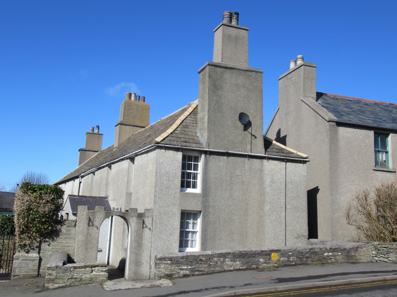
Earlier 19th century. 2-storey pair of 2, 3-bay near-symmetrical, rectangular-plan houses forming single, piended roofed block, orientated N-S with side elevation to street (S); Caithness-flagstoned close along W elevation; castellated entrance arch to main (W) elevations; single-storey, square-plan entrance porch to S property. Harled. Deep-set openings.
W (PRINCIPAL) ELEVATIONS: NORTH HOUSE: 2-leaf, part-glazed boarded doors at ground in bay to centre; window at 1st floor above. Window at each floor in each bay flanking. SOUTH HOUSE: window in entrance porch at ground in bay to centre; modern timber-panelled door in right return; window at 1st floor above. Window at each floor in each bay flanking.
S (EAST ROAD) ELEVATION: tall, extended central wallhead stack; window at each floor offset to outer right.
N (GARDEN) ELEVATION: tall, extended, central wallhead stack; window at each floor, offset to outer right; boarded door with window flanking lean-to addition to outer left.
Predominantly 12-pane timber sash and case windows. Traditional graded stone tiled roof, (S piend with replacement grey slates); stone ridge; harled, corniced, extended wallhead and ridge stacks; uPVC rainwater goods.
INTERIORS: not seen, 1998.
BOUNDARY WALLS; low rubble wall to S; higher rubble wall marking property division to W; rubble walls enclosing rectangular-plan garden to rear (N).
An intact pair of houses, with unusual piended roofs. The stacks are notably large and have been extended further. The retention of a near-complete traditionally stone slated roof and a traditinal Caithness-flagged walkway along the entrance elevations is of further interest.
External links are from the relevant listing authority and, where applicable, Wikidata. Wikidata IDs may be related buildings as well as this specific building. If you want to add or update a link, you will need to do so by editing the Wikidata entry.


Other nearby listed buildings
