Approximate Location Map
Large Map »
Latitude: 55.9375 / 55°56'14"N
Longitude: -4.6875 / 4°41'15"W
OS Eastings: 232229
OS Northings: 674866
OS Grid: NS322748
Mapcode National: GBR 0G.YWDJ
Mapcode Global: WH2MJ.Z102
Plus Code: 9C7QW8P6+XX
Entry Name: Lighthouse, West Quay, Port Glasgow
Listing Name: Port Glasgow Harbour, Lighthouse Opposite Warehouse on West Quay
Listing Date: 9 October 1990
Category: B
Source: Historic Scotland
Source ID: 385969
Historic Scotland Designation Reference: LB40086
Building Class: Cultural
ID on this website: 200385969
Location: Port Glasgow
County: Inverclyde
Town: Port Glasgow
Electoral Ward: Inverclyde East Central
Tagged with: Lighthouse
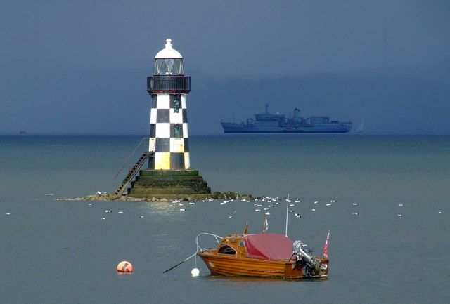
Built probably in 1860s and unaltered. Lighthouse, fat tapering cast-iron cylinder on circular stepped stone base, built on a rock which is exposed at low tide. Painted black with black and white chequering, plain rail balcony with "SLOW" sign facing west, triangular paned lantern with domed top. Iron steps to doorway.
External links are from the relevant listing authority and, where applicable, Wikidata. Wikidata IDs may be related buildings as well as this specific building. If you want to add or update a link, you will need to do so by editing the Wikidata entry.


Other nearby listed buildings
