Approximate Location Map
Large Map »
Latitude: 56.3413 / 56°20'28"N
Longitude: -2.7938 / 2°47'37"W
OS Eastings: 351024
OS Northings: 716837
OS Grid: NO510168
Mapcode National: GBR 2R.4G7Z
Mapcode Global: WH7S0.1WW0
Plus Code: 9C8V86R4+GF
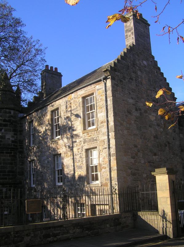
Entry Name: 71 North Street, St Andrews
Listing Name: 71 North Street.
Listing Date: 28 April 1959
Category: A
Source: Historic Scotland
Source ID: 386750
Historic Scotland Designation Reference: LB40770
Building Class: Cultural
Also known as: St Andrews, 71 North Street
ID on this website: 200386750
Location: St Andrews
County: Fife
Town: St Andrews
Electoral Ward: St Andrews
Traditional County: Fife
Tagged with: Architectural structure
Various dates from 15th cent. with interesting details from
16th and 17th cents. 3-storey, 3-window, rubble and slate
L-plan with stone spired roundel and gableted crowsteps W
gable; additions 1912 David Henry; front wall to street,
1790; w.i. railings and gate Reginald Fairlie, architect.
East gable rebuilt 1971.
External links are from the relevant listing authority and, where applicable, Wikidata. Wikidata IDs may be related buildings as well as this specific building. If you want to add or update a link, you will need to do so by editing the Wikidata entry.


Other nearby listed buildings
