Approximate Location Map
Large Map »
Latitude: 58.9616 / 58°57'41"N
Longitude: -3.2994 / 3°17'57"W
OS Eastings: 325365
OS Northings: 1008993
OS Grid: HY253089
Mapcode National: GBR L561.KBG
Mapcode Global: WH6B1.903S
Plus Code: 9CCRXP62+J7
Entry Name: 126 Victoria Street, Stromness
Listing Name: 124 and 126 Victoria Street, Including Quay
Listing Date: 24 March 1998
Category: C
Source: Historic Scotland
Source ID: 392341
Historic Scotland Designation Reference: LB45448
Building Class: Cultural
ID on this website: 200392341
Location: Stromness
County: Orkney Islands
Town: Stromness
Electoral Ward: Stromness and South Isles
Traditional County: Orkney
Tagged with: House
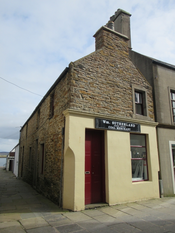
Earlier 19th century with later alterations. 2-storey, 3-bay (5-bay at ground) rectangular-plan house with 2-bay gabled W elevation, converted as shop at ground; adjoining 4-bay house (No 126) to E. Harl-pointed rubble; painted cement-rendered and lined to shop front. Cornice between floors to W. 1st floor windows hugging eaves; some cement margins to openings; stop chamfered NW angle.
N (PRINCIPAL) ELEVATION: ground floor: deep-set modern timber panelled door with large rectangular fanlight at ground in bay to right of centre; window, set close, in each bay flanking; modern 2-leaf boarded door with small-pane fanlight and flanking window to left, in bays to outer left. 3 evenly disposed windows at 1st floor above.
W (VICTORIA STREET) ELEVATION: 2-bay gabled elevation. Tall, 2-leaf, timber panelled door at ground to left. Shop window at ground to right; window at 1st floor; gablehead stack above.
Predominantly 4-pane timber sash and case windows. Caithness slate roof; stone ridge; stone skews; corniced rubble gablehead stacks to E and W.
INTERIOR: not seen, 1997.
QUAY: Caithness flagstones to large, rectangular-plan quay (partly grassed) to E with operational boat derrick, dated 1863, to NE angle.
Before number 126 was a Coal Office it was a shop varying from confectionery to a bakery to fish and chips.
External links are from the relevant listing authority and, where applicable, Wikidata. Wikidata IDs may be related buildings as well as this specific building. If you want to add or update a link, you will need to do so by editing the Wikidata entry.


Other nearby listed buildings
