Approximate Location Map
Large Map »
Latitude: 56.4376 / 56°26'15"N
Longitude: -2.9446 / 2°56'40"W
OS Eastings: 341851
OS Northings: 727668
OS Grid: NO418276
Mapcode National: GBR VL.B9ZG
Mapcode Global: WH7RJ.RG06
Plus Code: 9C8VC3Q4+25
Entry Name: 8 Boat Brae, Newport-On-Tay
Listing Name: 2-14 (Even Nos) Boat Brae
Listing Date: 27 November 2002
Category: B
Source: Historic Scotland
Source ID: 396537
Historic Scotland Designation Reference: LB49029
Building Class: Cultural
Also known as: Newport-on-tay, 8 Boat Brae
ID on this website: 200396537
Location: Newport-On-Tay
County: Fife
Town: Newport-On-Tay
Electoral Ward: Tay Bridgehead
Traditional County: Fife
Tagged with: Architectural structure
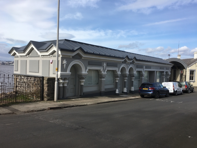
Charles & Leslie Ower, circa 1878, possibly incorporating earlier building. Row of 7 single storey shops, bold, squat, decorative Italianate design. Door and shop window to each shop; pilastered doorpieces; shouldered and round-headed arches to doors and windows; moulded star detail. Cream painted ashlar; raised painted ashlar panels in sandy yellow colour. Base course, eaves course.
E (PRINCIPAL) ELEVATION: corner angle to N (Nos 2 and 4). 2 adjacent doors with flanking shop windows; moulded shouldered arches to all openings.
No 2 abuts former ferry terminal
building. Corniced paired pilasters flank doors; fluted base; foliate capitals. Stop-chamfered square-plan piers with cornice, base course and advanced star detail to right of No 2 and left of No 4. Large opening for No 6 and 8 with plain, stop-chamfered central pier; flanking doors set within and large flanking shop windows. Round-arched doorways to Nos 10 and 12 with central and flanking single pilasters. Adjacent shop windows with square-plan piers. Star detail to centre and above piers. No 14 to far left; round-arched doorway; single pilaster and shop window to right; 2 terminating pilasters to left.
S ELEVATION: exposed rubble to lower half of gable; painted ashlar above with raised panels in contrasting colour.
W ELEVATION: partially seen (2002). Exposed rubble to rear elevation. A number of windows and stacks.
2-leaf round-headed timber panelled doors to Nos 10, 12 and 14. Timber and glazed doors with margin glazing to Nos 6 and 8. Replacement timber door to No 4; timber panelled door to No 2. Large plate glass shop windows with shouldered arches to all but Nos 6 and 8. Some windows boarded; fixed window to No 4 with astragals. Fittings for window security covers remain to No 12. Plate glass in timber sash and case windows to rear (W).
Pitched roof; grey slates to rear; lead to E with antifixa at ridges; felt to W. 3 gablets to S; raised at centre with surmounting antifixa (some missing). Gablet above Nos 10, 12 and 14. Projecting eaves to all but W elevation.
INTERIOR: partially seen, 2002. Shouldered arched doors and glazed panels to inner shop doors. Corner fireplaces; cast-iron grates; timber mantels. Timber tongue and groove panelling above dado; cornice. Window blinds to some shop windows.
A-Group with Newport Ferry Pier, Boat Road Former Ferry Terminal and Milestone. In 1878, C & L Ower (large architectural practice from Dundee) converted an existing boatshed, shop, waiting room and police station to create 7 shops including a butchers, tobacconists, police station, library, clothier and grocery and bakery.
Italianate in design with an almost colonnaded facade to its principal elevations and a plain functional appearance to its seaward side. Presumably, the adjacent ferry terminal building was built as a replacement at this time. These buildings sit in the area that was once the hub of Newport village. Newport began as the southern end of a successful ferry service across the Firth of Tay to Dundee and was once called New Dundee (for further information see Newport Ferry Pier listing).
The ferry service was superseded by a rail and road bridge, thus shifting the emphasis of Newport away from this area to its High Street. This building is currently empty (2002).
External links are from the relevant listing authority and, where applicable, Wikidata. Wikidata IDs may be related buildings as well as this specific building. If you want to add or update a link, you will need to do so by editing the Wikidata entry.


Other nearby listed buildings
