Approximate Location Map
Large Map »
Latitude: 57.1419 / 57°8'30"N
Longitude: -2.1071 / 2°6'25"W
OS Eastings: 393618
OS Northings: 805667
OS Grid: NJ936056
Mapcode National: GBR SB5.MT
Mapcode Global: WH9QQ.LRVB
Plus Code: 9C9V4VRV+P5
Entry Name: Brick Terrace, Bon Accord Crescent Gardens, Aberdeen
Listing Name: Brick Terrace Within Bon-Accord Crescent Gardens
Listing Date: 11 August 2003
Category: B
Source: Historic Scotland
Source ID: 396857
Historic Scotland Designation Reference: LB49361
Building Class: Cultural
ID on this website: 200396857
Location: Aberdeen
County: Aberdeen
Town: Aberdeen
Electoral Ward: Torry/Ferryhill
Traditional County: Aberdeenshire
Tagged with: Architectural structure
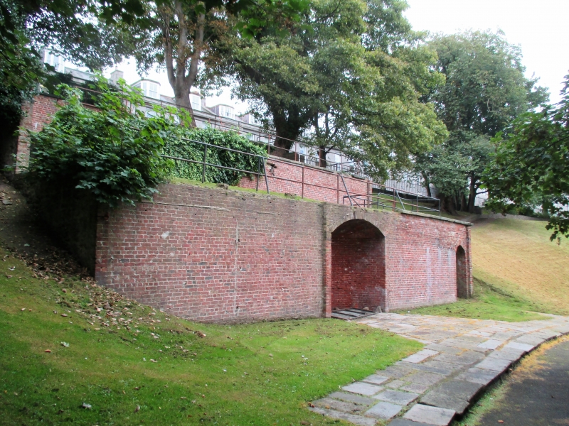
Earlier 19th century. 3-level garden terrace on steeply sloping site. Red brick faced; predominantly random stone rubble to side elevations. Predominantly flat or slightly bowed stone coping (several sections missing). Some stone flag paving to area in front of lowest level. Out of character modern metal railings to front and sides of all 3 levels.
LOWEST LEVEL: to centre, large segmentally-arched niche. To right, round-arched opening with modern gate leading to stone steps giving access to grassed platform above.
MIDDLE LEVEL: to left, stone steps leading to grassed platform above.
UPPER LEVEL: to right, stone steps leading to concrete paved platform above.
B-group with 1-19 (inclusive numbers) Bon Accord Crescent.
Listed as a good and relatively unusual extant example of earlier 19th century garden architecture.
The Bon Accord Gardens were originally formed as private gardens belonging to the houses of Bon Accord Crescent. The Crescent was designed by Archibald Simpson for the Incorporation of Tailors, and construction of the
houses began in 1823.
The gardens were formed on the south-west facing bank of the vale of the Howe Burn and were a major selling point of the Crescent (then known as Bon Accord Terrace). When they advertised feus in 1823, the Tailors stressed that 'the Terrace in particular commands an uninterrupted prospect of the south-west of the environs of the city and of the country to a great distance and overlooks the ground in the adjacent valley'. It is not clear precisely when the gardens were laid out but they were well established by the mid 1800s. The gardens were long strips, of varying widths running down the hill, divided by walls.
Several of them had terraces similar to this example, which were popular features in urban gardens of the early 19th century.
During the 20th century, Bon Accord gardens were in use as a market garden, with the upper sections used as allotments. In the 1970s, the market garden closed and the Gardens were landscaped to form an open area of public park. The remaining evidence of the original form of the gardens as private gardens was removed and only this single terrace survived these changes.
External links are from the relevant listing authority and, where applicable, Wikidata. Wikidata IDs may be related buildings as well as this specific building. If you want to add or update a link, you will need to do so by editing the Wikidata entry.


Other nearby listed buildings
