Approximate Location Map
Large Map »
Latitude: 56.593 / 56°35'34"N
Longitude: -3.3379 / 3°20'16"W
OS Eastings: 317936
OS Northings: 745367
OS Grid: NO179453
Mapcode National: GBR V8.TNHQ
Mapcode Global: WH6PF.PKP2
Plus Code: 9C8RHMV6+6R
Entry Name: Millbank House, 8 Upper Mill Street, Blairgowrie
Listing Name: Upper Mill Street, Millbank House Including Boundary Walls
Listing Date: 4 September 2003
Category: C
Source: Historic Scotland
Source ID: 397016
Historic Scotland Designation Reference: LB49483
Building Class: Cultural
ID on this website: 200397016
Location: Blairgowrie and Rattray
County: Perth and Kinross
Town: Blairgowrie And Rattray
Electoral Ward: Blairgowrie and Glens
Traditional County: Perthshire
Tagged with: Bank building
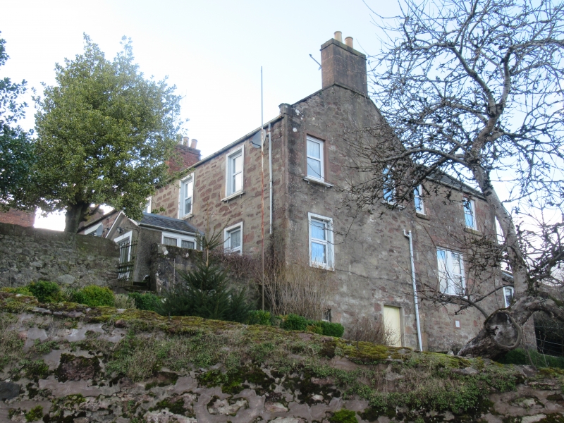
1839, extended to rear later 19th century. 2-storey, 3-bay house closing terrace to SW. Roughly coursed rubble with raised stone margins and harled porch.
SE (PRINCIPAL) ELEVATION: symmetrical. Later porch with modern door to centre at ground, windows in flanking bays and regular fenestration close to eaves at 1st floor, satellite dish to right.
NE ELEVATION: gabled bay to left with single window to left at each floor and further window to right at 1st floor. Asymmetrically-fenestrated lower wing to right.
Out-of-character PVCu glazing. Grey slates. Coped rubble stacks with thackstanes and cans. Ashlar-coped skews with flat skewputts.
INTERIOR: some moulded cornices; winding staircase with ironwork balusters and ball-finialled timber newel post. 2 cast-iron fireplaces, 1 with fine tiled cheeks depicting highland scene with stag. Carved timber fire surrounds to extension and further timber fire surround incorporating overmantel with mirror and Art Nouveau style detail.
Millbank house was built for William Davie an ironmonger with premises in Allan Street, but by 1841 was occupied by a writer. A branch of the Royal Bank was opened here in 1857 before moving to Allan Street in 1872.
External links are from the relevant listing authority and, where applicable, Wikidata. Wikidata IDs may be related buildings as well as this specific building. If you want to add or update a link, you will need to do so by editing the Wikidata entry.


Other nearby listed buildings
