Approximate Location Map
Large Map »
Latitude: 56.2124 / 56°12'44"N
Longitude: -2.7306 / 2°43'50"W
OS Eastings: 354782
OS Northings: 702442
OS Grid: NO547024
Mapcode National: GBR 2T.DJHB
Mapcode Global: WH7ST.130T
Plus Code: 9C8V6769+XQ
Entry Name: 11 Bruce's Wynd, Pittenweem
Listing Name: 11 Bruce’s Wynd, Pittenweem
Listing Date: 18 August 1972
Last Amended: 7 September 2016
Category: C
Source: Historic Scotland
Source ID: 406335
Historic Scotland Designation Reference: LB40025
Building Class: Cultural
Also known as: Pittenweem, 11 Bruce's Wynd
ID on this website: 200406335
Location: Pittenweem
County: Fife
Town: Pittenweem
Electoral Ward: East Neuk and Landward
Traditional County: Fife
Tagged with: Architectural structure
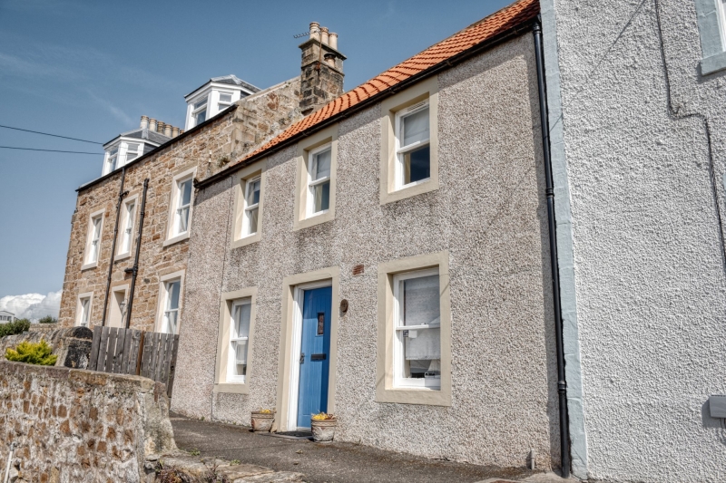
11 Bruce's Wynd is a typical late 18th century fisherman's cottage located on a narrow wynd near the harbour of Pittenween, a picturesque East Neuk of Fife coastal harbour village. The exterior has not been substantially altered and it retains its 18th century architectural details such as crowstepped gables, windows set close to the eaves and a small attic window in the west gable. The building also has special interest as an example of a fisherman's house which contributes to a group of buildings of similar date and type within the village.
Age and Rarity
Pittenweem is a fishing village in the East Neuk coast of Fife, renowned for its string of picturesque harbours and villages. Pittenweem became a royal burgh in 1541 after which permission was granted to build a harbour. The harbour was greatly expanded by Sir John Anstruther after 1770 to aid the distribution of his coal and salt production. During the 19th century it was the main fishing port for the East Neuk of Fife and it remains the most active of the fishing ports in the area. Pittenweem means 'place of the cave', referring to St Fillan's cave in nearby Cove Wynd which was used as a chapel by St Fillan in the 8th century.
11 Bruce's Wynd is a small fisherman's house located near the centre of the oldest part of village on a narrow pedestrian street, known as a 'wynd', between the harbour and the main street. The property is likely to have been built between 1770 and 1800, when fisherman houses were constructed because of the expansion of the harbour. It is located within the footprint of the old village as shown on John Ainslie's 1775 map of the County of Fife.
Houses in the harbour conservation area of the village are generally late 18th and 19th century 2-storey fisher cottages. 11 Bruce's Wynd is shown on the 1st Edition, 6 inch to the mile Ordnance Survey map (surveyed, 1854) at the west end of a row of buildings. The footprint of the building today remains the same as that shown on this map.
Architectural or Historic Interest
Interior
The interior has been refurbished and remodelled and no distinguishing features from the late 18th or 19th century are known to remain.
Plan form
The rear elevation of the property has a single door that provides access to the upper floor of the building. The upper floor of two-storey fisher houses was often used to store fishing nets during the 18th and 19th centuries. There is a small, raised platform to the rear garden which was likely used to dry the nets. These surviving elements are part of the early plan form interest.
The ground floor of this property has been altered from the traditional two room layout associated with this type of building, to form one large single space.
Technological excellence or innovation, material or design quality
Late 18th and early 19th century fisher houses are typically single storey or two-storey, symmetrically arranged houses, set in irregularly planned narrow streets. The construction and design of 11 Bruce's Wynd is therefore typical for a house of this date. The exterior of the property has not been significantly altered.
Crowstepped gables are a feature of many of the earlier buildings in Pittenweem and harling is typical for buildings close to the coast as it would provide protection to the stone from the salt water, and was easily maintained. The roofline remains unaltered with no later dormer windows or rooflight additions and the building lacks later openings to all elevations. The survival of the small attic window to the gable is of interest as an indication of the property's original function.
Setting
11 Bruce's Wynd forms part of a run of irregularly arranged fisher houses and cottages in the Pittenweem conservation area and are a key part of its historic character. The property is surrounded by a mix of 18th and 19th century cottages of vernacular architectural interest. 11 Bruce's Wynd is distinctive within this immediate setting because of its small and largely unaltered exterior form and its raised rear garden area.
Regional variations
The use of crowstep gables and terracotta pantiles are a characteristic feature of 18th century buildings in the fishing villages of the East Neuk coast of Fife.
Close Historical Associations
There are no known associations with a person or event of national importance at present (2016).
Statutory address, category of listing from B to C and listed building record revised in 2016. Previously listed as '11 Bruce's Wynd'.
External links are from the relevant listing authority and, where applicable, Wikidata. Wikidata IDs may be related buildings as well as this specific building. If you want to add or update a link, you will need to do so by editing the Wikidata entry.


Other nearby listed buildings
