History in Structure

Telephone Call-box outside The Post Office

A Grade II Listed Building in Holywell, Flintshire

More Photos »
Approximate Location Map
Large Map »

Coordinates

Latitude: 53.273 / 53°16'22"N

Longitude: -3.221 / 3°13'15"W

OS Eastings: 318673

OS Northings: 375808

OS Grid: SJ186758

Mapcode National: GBR 5ZYL.GF

Mapcode Global: WH76K.HZFQ

Plus Code: 9C5R7QFH+6J

Entry Name: Telephone Call-box outside The Post Office

Listing Date: 8 May 1990

Last Amended: 19 August 1991

Grade: II

Source: Cadw

Source ID: 450

Building Class: Communications

ID on this website: 300000450

Location: Set against the front wall of the Post Office, at right hand corner.

County: Flintshire

Community: Holywell (Treffynnon)

Community: Holywell

Built-Up Area: Holywell

Traditional County: Flintshire

Tagged with: Red telephone box

Find accommodation in
Holywell

History

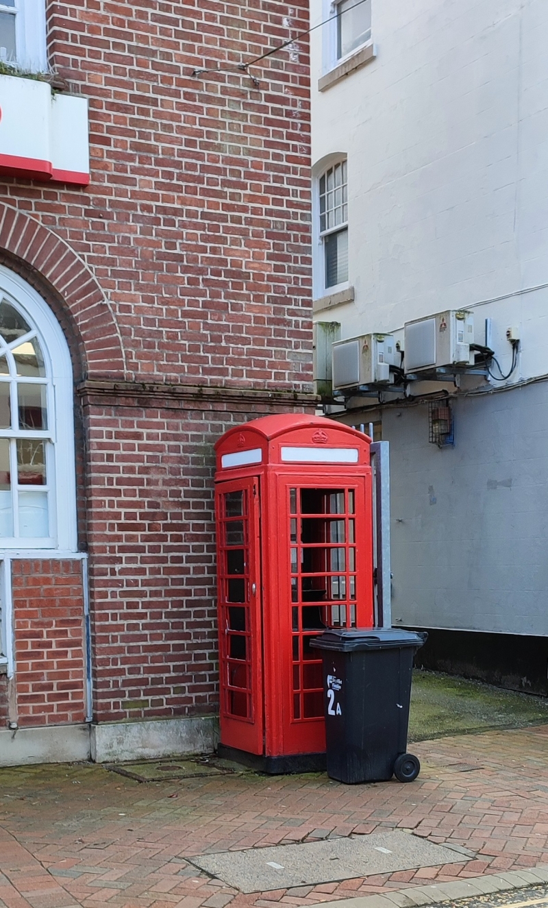
G VI R, K6 type. Square red kiosk of cast-iron construction to the standard design introduced by GPO in 1936. Foundry plate not visible.

Exterior

Domed roof with 4 lunettes containing embossed King George VI crowns over red lettered opals and ventilation slits. Raised surrounds with marginal bars to horizontal glazing. Blank rear, moulded plinth.

Reasons for Listing

Included for its group value in the town centre.

External Links

External links are from the relevant listing authority and, where applicable, Wikidata. Wikidata IDs may be related buildings as well as this specific building. If you want to add or update a link, you will need to do so by editing the Wikidata entry.

Recommended Books

Other nearby listed buildings

  • II Vron Chambers (John Morris & Co.)
    Set forward to right of King's Head Hotel; lane to right beside Post Office.
  • II The King's Head PH
    Detached to left, at the top (SE) end of the street by Victoria Square.
  • II 2
    Planned terrace leading off the SW side of the High Street; Memorial Gardens to SW end. Set in slope, facing Nos 14 to 29 (NW side).
  • II 1
    Planned terrace leading off the SW side of the High Street; Memorial Gardens to SW end. Set in slope, facing Nos 14 to 29 (NW side).
  • II 4
    Planned terrace leading off the SW side of the High Street; Memorial Gardens to SW end. Set in slope, facing Nos 14 to 29 (NW side).
  • II 3
    Planned terrace leading off the SW side of the High Street; Memorial Gardens to SW end. Set in slope, facing Nos 14 to 29 (NW side).
  • II National Westminster Bank
    On the corner with Panton Place towards the SE end of the street.
  • II NO.29 Panton Place, Clwyd
    Planned terrace leading off the SW side of the High Street; adjoins National Westminster Bank at NE end; Memorial Gardens to SW end. Set in the slope, facing Nos 1 to 13 (SE side).

BritishListedBuildings.co.uk is an independent online resource and is not associated with any government department. All government data published here is used under licence. Please do not contact BritishListedBuildings.co.uk for any queries related to any individual listed building, planning permission related to listed buildings or the listing process itself.

British Listed Buildings is a Good Stuff website.