History in Structure

NO.44 Well Street, Clwyd

A Grade II Listed Building in Holywell, Flintshire

More Photos »
Approximate Location Map
Large Map »

Coordinates

Latitude: 53.2758 / 53°16'32"N

Longitude: -3.2226 / 3°13'21"W

OS Eastings: 318571

OS Northings: 376122

OS Grid: SJ185761

Mapcode National: GBR 5ZYK.3F

Mapcode Global: WH76K.GXNK

Plus Code: 9C5R7QGG+8X

Entry Name: NO.44 Well Street, Clwyd

Listing Date: 19 August 1991

Last Amended: 19 August 1991

Grade: II

Source: Cadw

Source ID: 494

Building Class: Domestic

ID on this website: 300000494

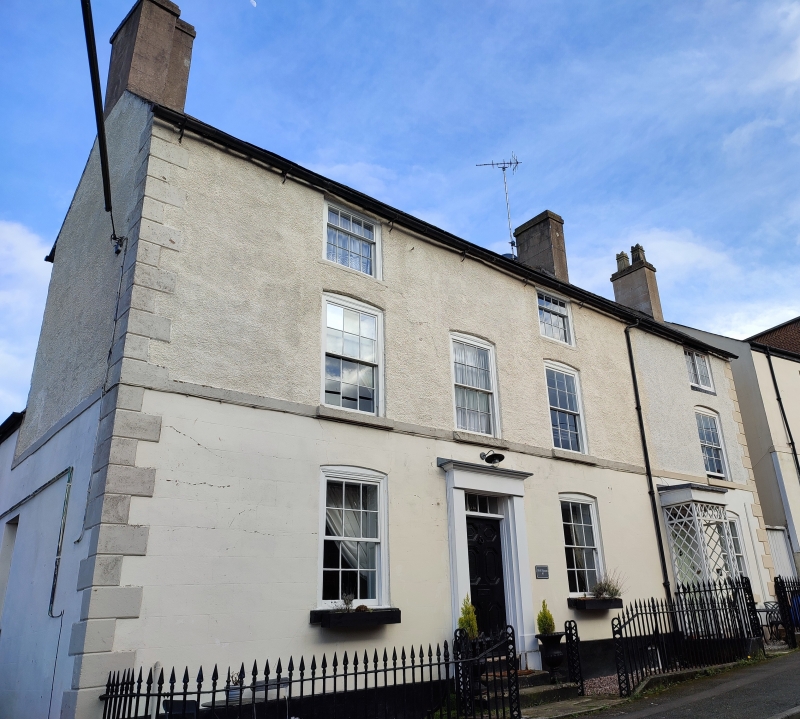
Location: Set in the slope opposite the Old Vicarage; detached to the right. Good forecourt railings with latticework, round-headed gateposts.

County: Flintshire

Community: Holywell (Treffynnon)

Community: Holywell

Built-Up Area: Holywell

Traditional County: Flintshire

Tagged with: Building

Find accommodation in
Holywell

History

Early C19

Exterior

3-storey, 1-window front; scribed cement render ground floor, pebbledash above and stone quoins and plinth. Slate roof with overhanging eaves. 1st floor sill continuous with No 46. Horned 12-pane sash windows, camber headed to 1st and ground floor. Modern trellised porch matching that to No 46. Octagonal and hexagonal panelled door with 4-pane overlight, as on No 46 and the Old Vicarage. Pebbledash right end with small cross range.

Reasons for Listing

Group value with N0 46 and the Old Vicarage.

External Links

External links are from the relevant listing authority and, where applicable, Wikidata. Wikidata IDs may be related buildings as well as this specific building. If you want to add or update a link, you will need to do so by editing the Wikidata entry.

Recommended Books

Other nearby listed buildings

  • II NO.46 Well Street, Clwyd
    Set in the slope opposite the Old Vicarage; detached to left. Good forecourt railings with latticework, round-headed gateposts.
  • II Old Vicarage
    Set in the slope above Plas Dewi to S of the St James' Parish Church. Red brick forecourt wall with low cast-iron railings; gated entry uphill with panelled gate piers.
  • II Presbytery at St.Winefride's Roman Catholic Church
    Adjoining the right hand side of St Winefride's RC Church; set in the slope with steeply terraced gardens to rear down to New Road.
  • II St Winefride's Roman Catholic Church
    On slopping site set back from the new road (A 5026). Presbytery to right.
  • II Pedestal & Statue of Christ (outside the former St. Winefride's school)
    On elevated site above the road, immediately N of St Winefride's Voluntary Primary School; facing downhill and set on a high pedestal. Reached by stone steps from the pavement.
  • II NO.8 Well Street, Clwyd
    Close to the NW end of High Street and with gable end facing modern road.
  • II NO.1 Well Street, Clwyd
    Detached and set back close to the NW end of the High Street; opposite No 8 and with side elevation facing modern road (A 5026).
  • II 1
    Prominently sited facing SE along the High Street.

BritishListedBuildings.co.uk is an independent online resource and is not associated with any government department. All government data published here is used under licence. Please do not contact BritishListedBuildings.co.uk for any queries related to any individual listed building, planning permission related to listed buildings or the listing process itself.

British Listed Buildings is a Good Stuff website.