History in Structure

Pont Eyarth

A Grade II Listed Building in Llanfair Dyffryn Clwyd, Denbighshire

More Photos »
Approximate Location Map
Large Map »

Coordinates

Latitude: 53.0877 / 53°5'15"N

Longitude: -3.3051 / 3°18'18"W

OS Eastings: 312691

OS Northings: 355298

OS Grid: SJ126552

Mapcode National: GBR 6S.9FNB

Mapcode Global: WH77H.6NF7

Plus Code: 9C5R3MQV+3X

Entry Name: Pont Eyarth

Listing Date: 19 July 1966

Last Amended: 12 February 2002

Grade: II

Source: Cadw

Source ID: 771

Building Class: Transport

Also known as: Pont Eyarth (partly in Llanfair Dyffryn Clwyd community)

ID on this website: 300000771

Location: Over the Avon Clwyd, 1km west of Llanfair Dyffryn Clwyd.

County: Denbighshire

Community: Llanfair Dyffryn Clwyd

Community: Llanfair Dyffryn Clwyd

Traditional County: Denbighshire

Tagged with: Bridge Road bridge

Find accommodation in
Llanfair-Dyffryn-Clwyd

History

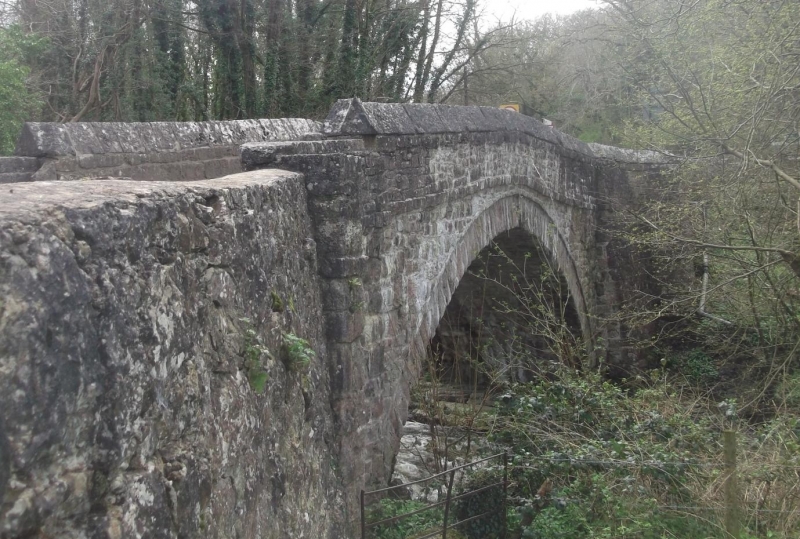
A fine county bridge of the C17 or C18.

Exterior

A bridge of a single large segmental arch in hammer-dressed local limestone masonry. The bridge common stonework is set slightly forward of the faces of the voussoirs, and there is a slight string course at the base of the parapet. At each end of the span on each face there is a slight turn-out to a buttress, and each corner is protected from traffic damage on the inside by means of a stone bollard. The carriageway rises gently from each side to a slight central hump, and is about 3½ metres wide between the parapets. The land approaches at both ends are faced in similar masonry but are a little wider.

The bridge parapets are massive and have triangular copings.

Reasons for Listing

A particularly fine county bridge which has fully retained its character.

External Links

External links are from the relevant listing authority and, where applicable, Wikidata. Wikidata IDs may be related buildings as well as this specific building. If you want to add or update a link, you will need to do so by editing the Wikidata entry.

Recommended Books

Other nearby listed buildings

  • II Pont Eyarth (partly in Llanfair Dyffryn Clwyd community)
    Spanning the Afon Clwyd at the eastern boundary of the community.
  • II Gatelodge to Eyarth House
    At entrance to grounds of Eyarth House, ½km west of Llanfair Dyffryn Clwyd.
  • II Limekiln
    Located approximately 100m SE of Pont Eyarth towards the eastern boundary of the community; built into a wooded slope adjacent to a disused quarry, set back from the road on the NW side.
  • II Eyarth House
    In private grounds 1km south west of Llanfair Dyffryn Clwyd.
  • II Cil y Groeslwyd-isaf
    Located in a slightly raised position off a track which leads W from Corwen Road. The house faces S.
  • II Nos.1-8 Elizabeth Owen Charity Almshouses
    At the west side of the village of Llanfair Dyffryn Clwyd, set back from the road behind an open green space and the war memorial.
  • II War Memorial
    In the centre of Llanfair Dyffryn Clwyd, in front of the Elizabeth Owen almshouses, in a low-walled paved area.
  • II Ceffyl Gwyn Public House
    In Llanfair Dyffryn Clwyd, opposite the Elizabeth Owen almshouses.

BritishListedBuildings.co.uk is an independent online resource and is not associated with any government department. All government data published here is used under licence. Please do not contact BritishListedBuildings.co.uk for any queries related to any individual listed building, planning permission related to listed buildings or the listing process itself.

British Listed Buildings is a Good Stuff website.