Approximate Location Map
Large Map »
Latitude: 51.8135 / 51°48'48"N
Longitude: -2.71 / 2°42'35"W
OS Eastings: 351151
OS Northings: 213003
OS Grid: SO511130
Mapcode National: GBR FL.WVTF
Mapcode Global: VH86T.ZP63
Plus Code: 9C3VR77R+C2
Entry Name: Old Toll House (Dixton Gate Turnpike)
Listing Date: 16 July 1973
Last Amended: 10 August 2005
Grade: II
Source: Cadw
Source ID: 2315
Building Class: Transport
ID on this website: 300002315
Location: On the historic north and east entry to the town, but now a cul-de-sac.
County: Monmouthshire
Town: Monmouth
Community: Monmouth (Trefynwy)
Community: Monmouth
Built-Up Area: Monmouth
Traditional County: Monmouthshire
Tagged with: Tollhouse
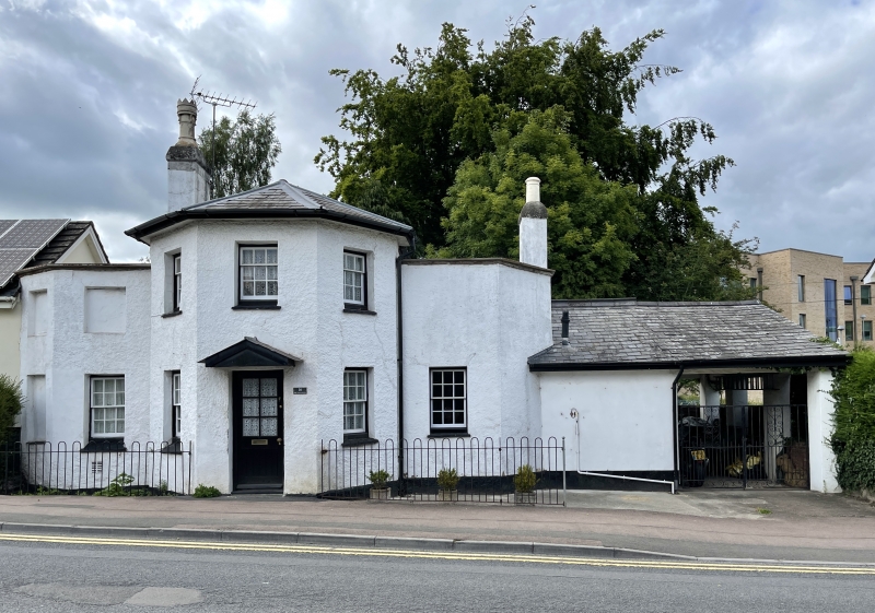
Early C19 toll house, which has been little altered externally. It must have been replaced by the one in Dixton Road (qv) after the new road was laid out in 1837.
Roughcast render and painted, probably over brick, with a Welsh slate roof. Half octagonal centre range with small flanking wings. Two storeys, three bay projecting entrance front. Pediment shaped hood over central doorway with plain replacement door. Window in each face, 6 over 6 pane sash below and 3 over 6 above. Single storey wing to either side, each with one ground floor window, blind recesses above and on the outside. Roof hipped to front of centre, hidden behind parapets to left and right, tall stack in angle between projecting front and left wing. Rear elevation not seen.
Interior not seen at resurvey.
Included for its special interest as an early C19 turnpike toll-house which has retained its character.
External links are from the relevant listing authority and, where applicable, Wikidata. Wikidata IDs may be related buildings as well as this specific building. If you want to add or update a link, you will need to do so by editing the Wikidata entry.


Other nearby listed buildings
