History in Structure

NOS.25 & 25A St.mary's Street, Gwent

A Grade II Listed Building in Monmouth, Monmouthshire

More Photos »
Approximate Location Map
Large Map »

Coordinates

Latitude: 51.8121 / 51°48'43"N

Longitude: -2.7131 / 2°42'47"W

OS Eastings: 350938

OS Northings: 212853

OS Grid: SO509128

Mapcode National: GBR FL.X1MV

Mapcode Global: VH86T.XQK5

Plus Code: 9C3VR76P+VQ

Entry Name: NOS.25 & 25A St.mary's Street, Gwent

Listing Date: 15 August 1974

Last Amended: 10 August 2005

Grade: II

Source: Cadw

Source ID: 2351

Building Class: Domestic

ID on this website: 300002351

Location: Part of a group in the important residential street leading south-east from the parish church.

County: Monmouthshire

Town: Monmouth

Community: Monmouth (Trefynwy)

Community: Monmouth

Built-Up Area: Monmouth

Traditional County: Monmouthshire

Tagged with: Building

Find accommodation in
Monmouth

History

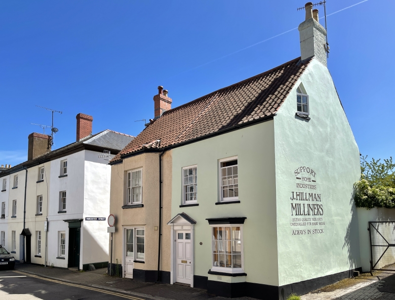
Late C18 house divided into two and altered in early C20.

Exterior

Roughcast rendered and painted with a tile roof. Double depth central entry plan of two storeys and garrets and three bays, now divided 1 : 2. Central doorcase (No.25) with reeded architrave, partially glazed 6-panel door. Projecting canted bay window on right with 5 x 3 panes. Altered projecting bay on left full height with modern door (No.25A) at centre ground floor, this has been set into an existing window, probably previously a tripartite sash as above. Fairly steeply pitched roof with gable stacks.
Small rear wing.

Interior

Interior not seen at resurvey.

Reasons for Listing

Included for its special architectural interest as an C18 house of definite character in the Monmouth town centre.

External Links

External links are from the relevant listing authority and, where applicable, Wikidata. Wikidata IDs may be related buildings as well as this specific building. If you want to add or update a link, you will need to do so by editing the Wikidata entry.

Recommended Books

Other nearby listed buildings

  • II 25A, St. Mary's Street
    Part of a group in the important residential street leading south-east from the parish church.
  • II 27, St. Mary's Street
    Part of a group in the important residential street leading south-east from the parish church.
  • II 29, St. Mary's Street
    Part of a group in the important residential street leading south-east from the parish church.
  • II St. Mary's Presbytery
    Part of a group in the important residential street leading south-east from the parish church.
  • II House including attached railings
    Part of a group in the important residential street leading south-east from the parish church.
  • II 28, St. Mary's Street
    Part of a group in the important residential street leading south-east from the parish church.
  • II 31, St. Mary's Street
    Part of a group in the important residential street leading south-east from the parish church.
  • II 30, St. Mary's Street
    Part of a group in the important residential street leading south-east from the parish church.

BritishListedBuildings.co.uk is an independent online resource and is not associated with any government department. All government data published here is used under licence. Please do not contact BritishListedBuildings.co.uk for any queries related to any individual listed building, planning permission related to listed buildings or the listing process itself.

British Listed Buildings is a Good Stuff website.