Latitude: 51.812 / 51°48'43"N
Longitude: -2.7126 / 2°42'45"W
OS Eastings: 350968
OS Northings: 212840
OS Grid: SO509128
Mapcode National: GBR FL.X1R6
Mapcode Global: VH86T.XQT8
Plus Code: 9C3VR76P+RX
Entry Name: NOS.37 & 39 St.mary's Street, Gwent
Listing Date: 15 August 1974
Last Amended: 10 August 2005
Grade: II
Source: Cadw
Source ID: 2353
Building Class: Domestic
ID on this website: 300002353
Location: Part of a group in the important residential street leading south-east from the parish church.
County: Monmouthshire
Town: Monmouth
Community: Monmouth (Trefynwy)
Community: Monmouth
Built-Up Area: Monmouth
Traditional County: Monmouthshire
Tagged with: Building
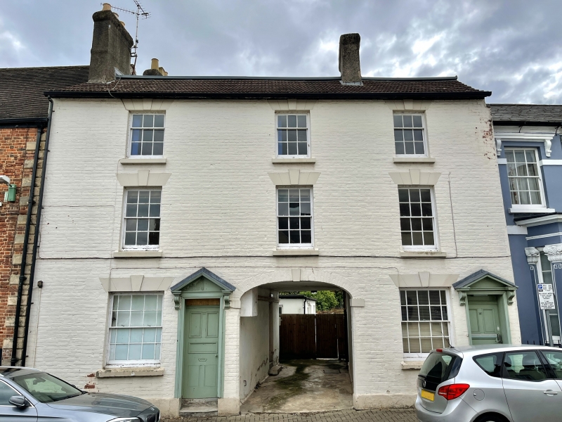
Early/mid C19 pair with a nearly symmetrical street facade but different planning for the two houses; they are externally unaltered.
Painted brick with a tile roof with brick stacks. Three storeys, three windows to whole. Double depth plan with doors to right. The ground floor has two windows, two doors and a central carriage arch arranged thus W : D : A : W : D. Keyed and imposted segmental arched carriage entry. Broken pedimented doorways with console brackets, transom lights over doors. Sash windows with 6 over 6 panes with additional half panes on either side, also keystones and voussoirs. First floor has similar 6 over 6 pane sashes, the second floor 3 over 6, all windows with stone cills. Low pitch roof with stacks on left gable and right side wall of carriage arch.
Rear elevation not seen.
This house has the rooms over the central arch.
Interior not seen at resurvey.
Included for its special architectural interest as a pair of early C19 houses of definite character in the Monmouth town centre.
External links are from the relevant listing authority and, where applicable, Wikidata. Wikidata IDs may be related buildings as well as this specific building. If you want to add or update a link, you will need to do so by editing the Wikidata entry.


Other nearby listed buildings