Approximate Location Map
Large Map »
Latitude: 51.9341 / 51°56'2"N
Longitude: -2.8807 / 2°52'50"W
OS Eastings: 339548
OS Northings: 226538
OS Grid: SO395265
Mapcode National: GBR FC.N82Y
Mapcode Global: VH78Q.0NY6
Plus Code: 9C3VW4M9+JP
Entry Name: Llangua Bridge
Listing Date: 9 November 1983
Last Amended: 19 October 2000
Grade: II
Source: Cadw
Source ID: 2762
Building Class: Transport
ID on this website: 300002762
Location: In Llangua over the River Monnow at county boundary between Monmouthshire and Herefordshire, on A465 road some 300m N of Monmouth Cap.
County: Monmouthshire
Town: Abergavenny
Community: Grosmont (Y Grysmwnt)
Community: Grosmont
Locality: Llangua
Traditional County: Monmouthshire
Tagged with: Bridge Road bridge
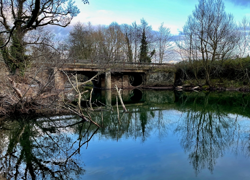
Bridge of c1827 designed by R G Thomas for Abergavenny-Hereford tramroad.
The purpose of this tramroad was to secure regular supplies of cheap coal to Hereford. Before the tramway, coal had to be laboriously transported up the River Wye by barge and navigation was expensive and erratic, particularly at times of winter flooding. By tramroad it was estimated that the price of Welsh coal could be cut by almost half, from 45 to 25 shillings a ton.
The tramway was completed in three stages. The first section (known as the Llanvihangel Railway) linked the Abergavenny and Brecon canal at Llanfoist to Llanvihangel Crucorney and opened on 12 March 1814. The second stage (the Grosmont Railway) continued the line to Llangua and was complete by 1819. Construction of the last section (the Hereford Railway) was delayed by over 5 years, but received a boost in February 1824, with the foundation of the Hereford Gas Company.
On Monday 21 September 1829 the line finally opened. 15 tramloads of coal from Thomas Hill's colliery at Blaenavon arrived in Hereford and 10.5 tons of coal was distributed free amongst the town's poor.
Red sandstone rubble with ashlar dressings. Low bridge of four arches with stone voussoirs; smaller outer arches are semi-circular, centre two segmental. E side has splayed centre breakwater which rises to form canted parapet wall. Iron railings to former tramway bridge have been removed to accommodate widened roadway and C20 safety barrier.
Impressively large tramroad bridge of early C19, despite C20 alterations.
External links are from the relevant listing authority and, where applicable, Wikidata. Wikidata IDs may be related buildings as well as this specific building. If you want to add or update a link, you will need to do so by editing the Wikidata entry.


Other nearby listed buildings
