Approximate Location Map
Large Map »
Latitude: 51.6132 / 51°36'47"N
Longitude: -2.8332 / 2°49'59"W
OS Eastings: 342403
OS Northings: 190813
OS Grid: ST424908
Mapcode National: GBR JD.9Q13
Mapcode Global: VH7B8.VQ26
Plus Code: 9C3VJ578+7P
Entry Name: Parish Church of St John the Baptist
Listing Date: 1 March 1963
Last Amended: 19 December 1995
Grade: II
Source: Cadw
Source ID: 2937
Building Class: Religious, Ritual and Funerary
ID on this website: 300002937
Location: Located immediately to the SE of Penhow Castle, reached via a long track leading S from the A48, enclosed by a low rubble wall.
County: Newport
Community: Penhow (Pen-hw)
Community: Penhow
Locality: Penhow Castle
Traditional County: Monmouthshire
Tagged with: Church building
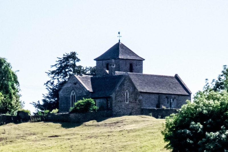
C12 origins, mostly dating from the C13 when the S aisle was added. South porch probably C15. Nave and chancel re-roofed in the C18 with plastered barrel vaulting. Heavily restored in 1914 with donations from Lady Perry-Herrick, then owner of Penhow Castle. At this time, the tower was rebuilt, the vestry were added and the church was refenestrated and refitted internally, including the restoration and partial replacement of the rood screen.
Distinctive plan consisting of: chancel, stepping up to the nave, small vestry to N of the chancel, S aisle with square, pyramidal roofed tower bisecting the aisle into two equal halves, the tower crossing leads into the S porch. Constructed of local rubblestone, with stone dressings and slate roofs. All windows date from the early C20 restoration unless otherwise stated. The E window of the chancel is a cusped, two-light window with quatrefoil to the head. The chancel is lit on the S side with a similar window with a simple hoodmould beneath a relieving arch. The E end of the S aisle has a small stained glass lancet, set at high level. The S aisle is lit by a pair of matching two-light windows with quatrefoil to the head which flank the porch. The porch has a simple roundheaded doorway with benches either side and a C13 stoup set to the right hand side of the inner door. The porch is set slightly off-centre to the S face of the tower. W window of S aisle is a small single window with cusped head set at high level. The W window of the nave is slightly larger with four-centred doorway beneath, with relieving arch over. Large, stepped buttress set at the junction of the nave and S aisle. The nave is lit on the N side by two, three-light windows with cusped heads, one at each end. Vestry is lit on the W and N sides. Tower has single louvered belfry windows to each elevation with redbrick dressings and stone cills with flanking pairs of slot windows set under the eaves of the hipped slate roof.
Stone steps of the churchyard cross survive to the S of the porch within the graveyard precincts.
South porch leads into the tower crossing. The S aisle has an arcade of five bays in exposed sandstone rubble with plain pointed arches, the central arch supports the tower above on massive piers. The E bay of the S aisle was allegedly the former Seymour chapel. The flanking arches have chamfered pointed arches with a variety of detail: to the far left at the chancel end is a round column with a diagonally undercut capital with roll moulding above, to the right of this is another round column with a decorative still leaf capital, to the right of the tower crossing at the W end is an octagonal engaged column with a diagonally undercut capital with broach stops beneath it. The chancel arch is wide, high and obtuse and probably rebuilt at the time of the new roof during the C18. Low plain stone carved screen divides the chancel and nave with a central doorway and horizontal members spring from the top of the jambs of the doorway to create square squints to either side. At the W end of the S aisle is circular font, set on a square base. On the N side of the chancel is the exposed top half of the Seymour tomb set into the wall, taking the form of an ogee niche with cusped interior and flamboyant crockets. The chancel retains a C13 double piscina to the right hand side of the altar.
Listed grade II for its early origins, surviving medieval fabric and group value with Penhow Castle.
External links are from the relevant listing authority and, where applicable, Wikidata. Wikidata IDs may be related buildings as well as this specific building. If you want to add or update a link, you will need to do so by editing the Wikidata entry.


Other nearby listed buildings
