Latitude: 52.9649 / 52°57'53"N
Longitude: -4.2249 / 4°13'29"W
OS Eastings: 250670
OS Northings: 343150
OS Grid: SH506431
Mapcode National: GBR 5L.K65S
Mapcode Global: WH55C.2QFX
Plus Code: 9C4QXQ7G+W3
Entry Name: Parish Church of St Mary
Listing Date: 19 October 1971
Last Amended: 30 March 1999
Grade: II*
Source: Cadw
Source ID: 4278
Building Class: Religious, Ritual and Funerary
Also known as: St Mary's Church, Dolbenmaen
ID on this website: 300004278
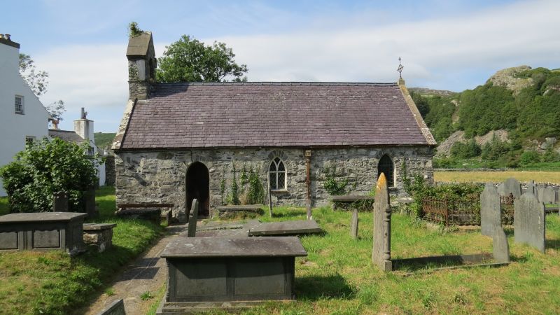
Location: The parish church lies on a small by-passed section of the main road at the junction with the Cwm Pennant road. It stands within an irregularly shaped graveyard and is approached through a lych gate.
County: Gwynedd
Town: Dolbenmaen
Community: Dolbenmaen
Community: Dolbenmaen
Traditional County: Caernarfonshire
Tagged with: Church building
The church originated as a chapelry of St Beuno, Penmorfa, and was built in the C15, from which period the roof survives. It has been considerably altered at later dates. Now combined as the parish of Dolbenmaen with Penmorfa.
A small single cell building constructed with uncoursed local rubble stone with long stone quoins, all partially rendered, with a C19 slate roof between raised gable parapets. The S door is near the W end, a pointed arch containing a C19 boarded door with ornamental ironwork. Pointed headed windows both sides, that at the centre of the S side having diamond leaded glazing set in timber transomed 'Y'-tracery, with another further E, and a similar window opposite on the N side. The E window is round headed. The W wall has been rebuilt, and has a square headed high set W window, and corbelled gabled bellcote surmounted by a small stone cross. A slate sundial of the early C19 is set on the S side.
Wall plastered throughout. Roof of 5 bays, defined by C15 arch-braced collar beam trusses with cusped king posts and soffits of the principal rafters, which rise directly from the walls. Windbraces to 2 tiers of purlins. Boarded soffit to the E bay over the chancel at arch-brace level forming a shallow barrel vault. Tiled floor, the chancel raised by a single step. Timber altar rail on iron scrolled stanchions. Reredos behind the altar, formed from the frontal of the former W gallery. Three corbels at the W end are probably the remains of beams supporting the W gallery, lit by the high W window.
Fittings: pulpit, C19, of stained wood. Altar of 1931.
Glass: E window, an Agnus Dei, and S window, 1937 by J A Brymer.
Monuments: on the N wall, engraved slate tablet to Lowry Wynne of Rhwngyddwyrid, d.1719.
Included at II* largely for the survival of medieval fabric including the fine roof structure which appears unaltered.
External links are from the relevant listing authority and, where applicable, Wikidata. Wikidata IDs may be related buildings as well as this specific building. If you want to add or update a link, you will need to do so by editing the Wikidata entry.


Other nearby listed buildings