History in Structure

Barn and cartsheds, Penrhos Home Farm

A Grade II Listed Building in Trearddur, Isle of Anglesey

More Photos »
Approximate Location Map
Large Map »

Coordinates

Latitude: 53.3018 / 53°18'6"N

Longitude: -4.5963 / 4°35'46"W

OS Eastings: 227087

OS Northings: 381462

OS Grid: SH270814

Mapcode National: GBR HM0Z.CCD

Mapcode Global: WH42H.C8JL

Plus Code: 9C5Q8C23+PF

Entry Name: Barn and cartsheds, Penrhos Home Farm

Listing Date: 22 February 1993

Last Amended: 30 June 1998

Grade: II

Source: Cadw

Source ID: 5767

Building Class: Agriculture and Subsistence

ID on this website: 300005767

Location: Located at the heart of the Penrhos Coastal Park at the SE end of Holy Island; reached by private driveway N of the A5(T) and c1.25km NNE of the N end of the Stanley Embankment; this range at E side o

County: Isle of Anglesey

Community: Holyhead (Caergybi)

Community: Holyhead

Locality: Penrhos Coastal Park

Traditional County: Anglesey

Tagged with: Barn

Find accommodation in
Holyhead

History

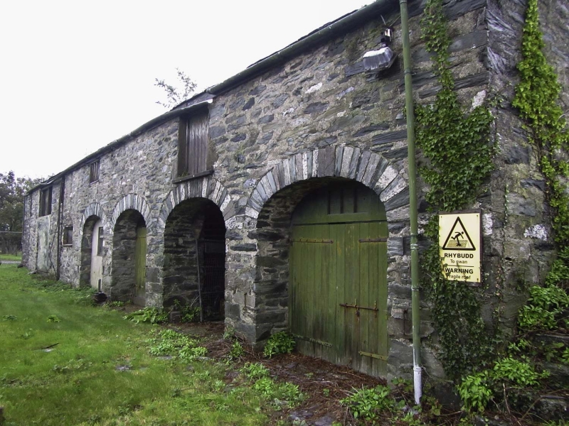
The Penrhos estate was the principal seat on Holy Island and became the home of the Stanley family in 1763. Penrhos house was completely remodelled for John Thomas Stanley in early C19; the barn and cartshed range (part of the home farm) is probably contemporary with this remodelling. The house became ruinous after 1945 and was later almost entirely demolished. The estate was bought by Anglesey Aluminium in 1969 and made into a country park in 1972. The estate buildings were being refurbished when inspected, May 1997.

Exterior

Lofted agricultural range comprising barn and cartsheds; rubble with grouted slate roof. The four distinctive segmental arches to right have local green and quartz banded boussoirs; the left hand arch has been infilled (shown open in view of 1915). Granary above, the right hand opening of which was enlarged after 1915 to create a boarded loft door. Outside stone steps against right hand gable end with similar boarded door and banded voussoirs. Barn to left has full height split boarded doors and slit ventilator to end. Blocked opening to left gable end; skylights.

Reasons for Listing

Listed as a well-detailed estate building forming a group with the Baillifs Tower at Penrhos Home Farm.

External Links

External links are from the relevant listing authority and, where applicable, Wikidata. Wikidata IDs may be related buildings as well as this specific building. If you want to add or update a link, you will need to do so by editing the Wikidata entry.

Recommended Books

Other nearby listed buildings

  • II Bailiff's Tower and with boundary wall, gates and attached outbuildings at Penrhos Home Farm
    Located at the heart of the Penrhos Coastal Park at the SE end of Holy Island; reached by private driveway N of the A5(T) and c1.25km NNE of the N end of the Stanley Embankment. The Bailiff's Tower li
  • II Tower, walls and courtyard buildings
    Located at the heart of the Penrhos Coastal Park at the SE end of Holy Island; reached by private driveway N of the A5(T) and c1.25km NNE of the N end of the Stanley Embankment. The tower is adjacent
  • II Candle Tower and walls adjoining remains of Penrhos House
    Located at the heart of the Penrhos Coastal Park at the SE end of Holy Island; reached by private driveway N of the A5(T) and c1.25km NNE of the N end of the Stanley Embankment. The Candle Tower and w
  • II The Battery
    On the headland at the NW edge of the park; Penrhos Beach below to W. Penrhos Coastal Park lies at the SE end of Holy Island.
  • II Watertower
    Located at the heart of the Penrhos Coastal Park at the SE end of Holy Island; reached by private driveway N of the A5(T) and c1.25km NNE of the N end of the Stanley Embankment. The Watertower is at S
  • II The Betting Stand (aka Rotten Tower)
    Situated towards the southern end of the park at the edge of woodland and overlooking the broad expanse known as Penrhyn Quillet. Penrhos Coastal Park lies at the SE end of Holy Island.
  • II Stanley Tollhouse
    Set back from the N side of the A5(T), directly over the northern end of the Stanley Embankment and within Penrhos Coastal Park.
  • II Telford Milestone
    Located at the NE side of the A5 directly over the N end of the Stanley Embankment.

BritishListedBuildings.co.uk is an independent online resource and is not associated with any government department. All government data published here is used under licence. Please do not contact BritishListedBuildings.co.uk for any queries related to any individual listed building, planning permission related to listed buildings or the listing process itself.

British Listed Buildings is a Good Stuff website.