History in Structure

Gazebo

A Grade II Listed Building in Crickhowell, Powys

More Photos »
Approximate Location Map
Large Map »

Coordinates

Latitude: 51.8615 / 51°51'41"N

Longitude: -3.1377 / 3°8'15"W

OS Eastings: 321751

OS Northings: 218708

OS Grid: SO217187

Mapcode National: GBR F0.SY22

Mapcode Global: VH6CH.KGLV

Plus Code: 9C3RVV66+HW

Entry Name: Gazebo

Listing Date: 25 September 1986

Last Amended: 25 September 1986

Grade: II

Source: Cadw

Source ID: 7161

Building Class: Gardens, Parks and Urban Spaces

ID on this website: 300007161

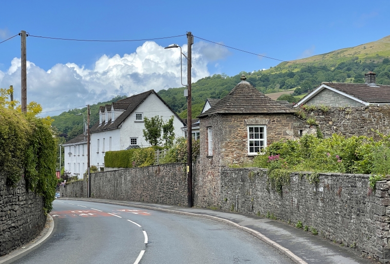
Location: Set into a long rubble wall flanking the A40 opposite the crenellated wall of Porth Mawr.

County: Powys

Town: Crickhowell

Community: Crickhowell (Crughywel)

Community: Crickhowell

Built-Up Area: Crickhowell

Traditional County: Brecknockshire

Tagged with: Architectural structure

Find accommodation in
Crickhowell

History

Early C19 (shown on 1840 Tithe Map) low

Exterior

2-storey rubble square building with dreseed quoins. Stone tiled pyramidal roof with finial and swept eaves. Modern 12-pane windows recently inserted on 2 sides; smaller window to NW side beside boarded door up steps. Blocked opening to SW road side formerly leading to nail making shop.

Reasons for Listing

One of 3 in the town used formerly by inns as look-out towers to watch for the arrival of coaches.

External Links

External links are from the relevant listing authority and, where applicable, Wikidata. Wikidata IDs may be related buildings as well as this specific building. If you want to add or update a link, you will need to do so by editing the Wikidata entry.

Recommended Books

Other nearby listed buildings

  • II Ashfield
    On an elevated site at the bottom of Rectory Road on the corner with Brecon Road; reached by a short driveway entered between rubble gate piers and pointed wooden gates.
  • II St David's Rectory
    At the top of, and at right angles to, the road, facing SW with garden sloping steeply to front.
  • II Boundary wall running north from Porth Mawr Gate-house to Pen-y-dre Lodge
    Enclosing the Herbert family castellated mansion, Cwrt-y-Crw, but now forming a garden wall to Porth Mawr House, some modern houses and Pen-y-Dre Lodge.
  • II NO.1 Llanbedr Road, Powys
    Near the junction with Brecon Road, the western end of a splayed terrace stepped in the slope.
  • II NO.2 Llanbedr Road, Powys
    Near the junction with Brecon Road, the western end of a splayed terrace stepped in the slope
  • II NO.3 Llanbedr Road, Powys
    Rear the junction with Brecon Road, the western end of a splayed terrace stepped in the slope.
  • I Porth-Mawr Gatehouse
    Forward to the street and set into a long rubble crenelated wall now enclosing Porth Mawr house but formerly the castellated Herbert family mansion called Cwrt-y-Carw. Gatehouse adjoins side of house
  • II NO.4 Llanbedr Road, Powys
    Around the corner from Nos 1, 2 and 3; part of a terrace stepped in the slope.

BritishListedBuildings.co.uk is an independent online resource and is not associated with any government department. All government data published here is used under licence. Please do not contact BritishListedBuildings.co.uk for any queries related to any individual listed building, planning permission related to listed buildings or the listing process itself.

British Listed Buildings is a Good Stuff website.