Approximate Location Map
Large Map »
Latitude: 52.4994 / 52°29'57"N
Longitude: -3.3331 / 3°19'59"W
OS Eastings: 309602
OS Northings: 289891
OS Grid: SO096898
Mapcode National: GBR 9R.HQ1D
Mapcode Global: VH689.5FST
Plus Code: 9C4RFMX8+QQ
Entry Name: Castell-y-Dail Farmhouse
Listing Date: 9 May 1988
Last Amended: 9 May 1988
Grade: II
Source: Cadw
Source ID: 8206
Building Class: Domestic
ID on this website: 300008206
Location: Below Castell-y-Dail woods at the end of a farm off Mochre Lane, near the College Farm.
County: Powys
Community: Newtown and Llanllwchaiarn (Y Drenewydd a Llanllwchaearn)
Community: Newtown and Llanllwchaiarn
Locality: Maesyrhandir
Built-Up Area: Newtown
Traditional County: Montgomeryshire
Tagged with: Farmhouse
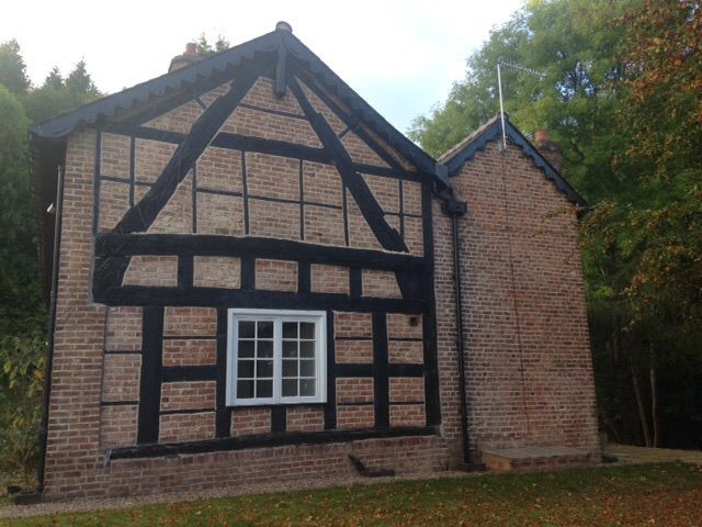
Mid C19
L-shaped farmhouse with earlier origins. 2 storey, 3 window front. Flemish bond brick. Gently pitched slate roof, hipped to left. Deep eaves and verges, ornamental bargeboards. Tall twin octagonal flues on rectangular base to central brick stack. 3 light casement windows flank central 2 light window to 1st floor. Broader 2 light casements to ground floor, cambered header arches. Plain central doorway, cambered head. (Formerly lobby entry). Right and elevation timber framed. High collarded cruck, later tennoned tie beam. Blades removed below elbow with later beam on square framing. Eaves raised with light C19 framing. Left elevation similar to main front, with later range added to rear.
Contemporary, 2 storey brick outhouse; gabled slate roof, brick end stack.
Single stop chamfered axial ceiling beam to room adjoining timber framed gable.
External links are from the relevant listing authority and, where applicable, Wikidata. Wikidata IDs may be related buildings as well as this specific building. If you want to add or update a link, you will need to do so by editing the Wikidata entry.


Other nearby listed buildings
