Approximate Location Map
Large Map »
Latitude: 52.4107 / 52°24'38"N
Longitude: -4.0856 / 4°5'8"W
OS Eastings: 258236
OS Northings: 281231
OS Grid: SN582812
Mapcode National: GBR 8R.PBP2
Mapcode Global: VH4FC.4NGV
Plus Code: 9C4QCW67+7Q
Entry Name: Malthouse Kiln including B & D Joinery Warehouse (formerly listed as Oasthouse only)
Listing Date: 24 November 1987
Last Amended: 24 November 1987
Grade: II
Source: Cadw
Source ID: 10423
Building Class: Industrial
ID on this website: 300010423
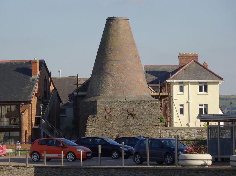
Location: Situated to the S of Pont Aberystwyth, the malting kiln forming an important landmark overlooking the harbour.
County: Ceredigion
Community: Aberystwyth
Community: Aberystwyth
Built-Up Area: Aberystwyth
Traditional County: Cardiganshire
Tagged with: Warehouse
Malthouse shown on ca 1790 map, kiln added by 1860s; restored in 1981.
Coursed colourwashed rubble 3-storey, 2-window street frontage with slate roof; left hand bay advanced and gable ended with projecting gabled canopy to hoist. Voussoir lintels, pivot windows and boarded doors and one part glazed door to first floor left. Boarded up casement windows to side.
Fine malt-drying kiln adjoins at rear; a rare well preserved example of its type. Set upon high square rubble base with iron brace plates; conical brick kiln chimney rises above with twin cement rendering; cowl missing.
Internally the warehouse retains pegged king post trusses, typical of the period; cast iron columns and stop chamfered tie beams. The kiln is reached through a small narrow arched opening with boarded doors. This kiln is particularly special in retaining its perforated tile floor.
Blocked former limekiln (shown on 1809 map) adjoins to right.
Group Value.
External links are from the relevant listing authority and, where applicable, Wikidata. Wikidata IDs may be related buildings as well as this specific building. If you want to add or update a link, you will need to do so by editing the Wikidata entry.


Other nearby listed buildings
