Approximate Location Map
Large Map »
Latitude: 52.1123 / 52°6'44"N
Longitude: -4.2774 / 4°16'38"W
OS Eastings: 244149
OS Northings: 248448
OS Grid: SN441484
Mapcode National: GBR DH.93N4
Mapcode Global: VH3KB.T52J
Plus Code: 9C4Q4P6F+W2
Entry Name: Yr Efail
Listing Date: 13 January 1993
Last Amended: 13 January 1993
Grade: II
Source: Cadw
Source ID: 10594
Building Class: Domestic
ID on this website: 300010594
Location: Situated at right angles to road opposite drive to Castell Hywell.
County: Ceredigion
Community: Llandysul
Community: Llandysul
Locality: Castell Hywel
Traditional County: Cardiganshire
Tagged with: Cottage
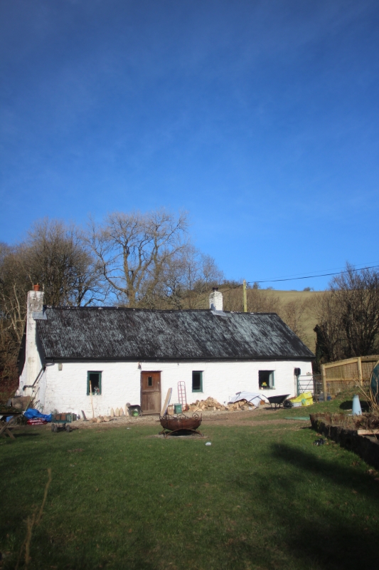
Said to be recorded back to 1724.
C18 small cottage, single storey and loft, rubble stone, whitewashed with corrugated iron roof, formerly thatched. Brick stack on ridge at original E end. Original cottage has centre door and window each side, C20 glazing. E addition has one window.
Hewn centre beams to ground floor. Collar trusses to roof with scarfed cruck joints and wavy collar pieces. Four bays. Chimney end has small collar carrying Y-shaped ridge support. Original stair removed and modern stair added in E end section.
A good example of small single storey and loft cottage of regional type.
External links are from the relevant listing authority and, where applicable, Wikidata. Wikidata IDs may be related buildings as well as this specific building. If you want to add or update a link, you will need to do so by editing the Wikidata entry.


Other nearby listed buildings
