Latitude: 52.9828 / 52°58'57"N
Longitude: -3.3263 / 3°19'34"W
OS Eastings: 311053
OS Northings: 343648
OS Grid: SJ110436
Mapcode National: GBR 6R.J2J1
Mapcode Global: WH781.W975
Plus Code: 9C4RXMMF+4F
Entry Name: Farmbuildings at Llan Farm
Listing Date: 1 February 1995
Last Amended: 1 February 1995
Grade: II
Source: Cadw
Source ID: 15546
Building Class: Agriculture and Subsistence
ID on this website: 300015546
Location: On the N of the village, on the SW side of the lane which leads to Bryneglwys via Morfydd, opposite and below Llan Farmhouse and Llan House.
County: Denbighshire
Community: Corwen
Community: Corwen
Locality: Carrog
Traditional County: Merionethshire
Tagged with: Agricultural structure
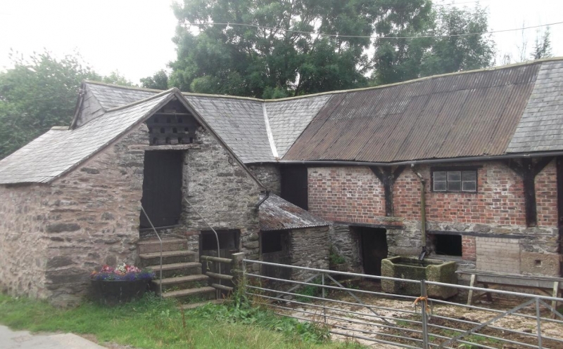
Probably C17- C18, built in several phases.
The main buildings form an L-plan range, with barn and shippons enclosing 2 sides of a yard, with a further building built across the gable end of the shippon and forming a short range in the front of the yard (possibly originally a stable). This building has loft doorway in gable end facing the yard, up renewed stairs. Nesting boxes incorporated in gable apex. Barn forms boundary of yard to SW and may be C17: rubble ground floor, with braced timber posts and brick panel infill forming 3 bays above. Heavy principal trusses with short queen struts. Double doors to right, and loft door up steps to left. Line shafting and some farm machinery (?early C20) survives in upper floor. Shippon (probably C18) forms SE range and faces outwards from the yard, with 3 doorways with rough timber lintels.
An early group of farmbuildings, representative of local traditions of layout and construction, of types now rarely surviving intact. Part of a group with the nearby Llan Farmhouse and Llan House.
External links are from the relevant listing authority and, where applicable, Wikidata. Wikidata IDs may be related buildings as well as this specific building. If you want to add or update a link, you will need to do so by editing the Wikidata entry.


Other nearby listed buildings