History in Structure

Pont Abercaseg

A Grade II Listed Building in Bethesda, Gwynedd

More Photos »
Approximate Location Map
Large Map »

Coordinates

Latitude: 53.1761 / 53°10'33"N

Longitude: -4.0507 / 4°3'2"W

OS Eastings: 263037

OS Northings: 366296

OS Grid: SH630662

Mapcode National: GBR 5T.3SLV

Mapcode Global: WH54G.RF8H

Plus Code: 9C5Q5WGX+CP

Entry Name: Pont Abercaseg

Listing Date: 25 April 1997

Last Amended: 25 April 1997

Grade: II

Source: Cadw

Source ID: 18382

Building Class: Transport

ID on this website: 300018382

Location: Situated some 300m S of centre of Bethesda near football club pavilion.

County: Gwynedd

Town: Bangor

Community: Bethesda

Community: Bethesda

Built-Up Area: Bethesda

Traditional County: Caernarfonshire

Tagged with: Bridge Road bridge

Find accommodation in
Bethesda

History

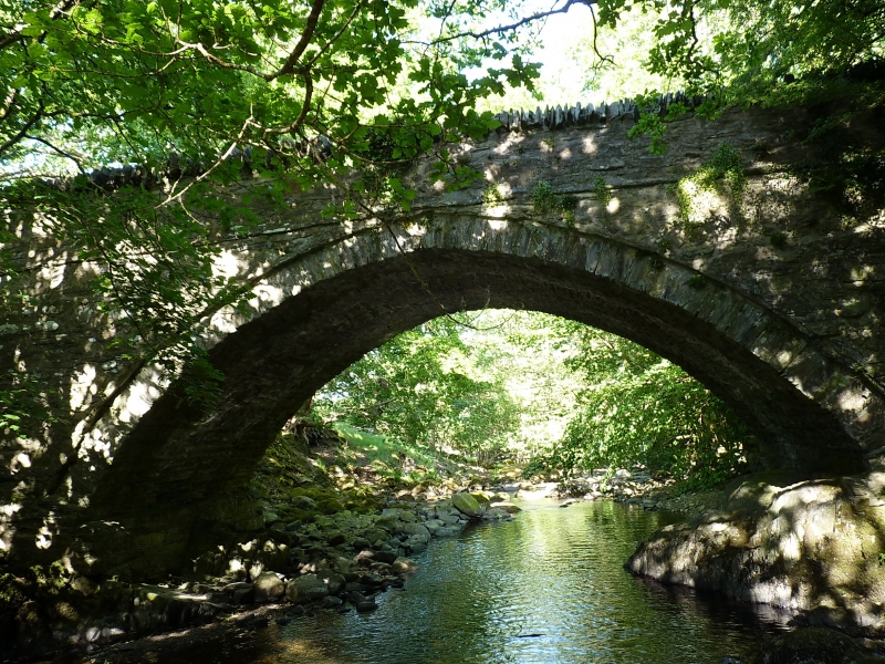
Late C18 road bridge over River Caseg. On minor lane that was old road from Pont Twr on Ogwen to Llanllechid, superseded by Telford's main road c1820. Mentioned c1810 as bridge over the Caseg on road from Talybont to Pont y Twr.

Exterior

Rubble stone single arched road bridge of broad span, high over river. Elliptical arch with stone voussoirs in recessed arch-rings. Rubble stone parapets with some slate coping.

Reasons for Listing

A good road bridge dating from before the main turnpike system.

External Links

External links are from the relevant listing authority and, where applicable, Wikidata. Wikidata IDs may be related buildings as well as this specific building. If you want to add or update a link, you will need to do so by editing the Wikidata entry.

Recommended Books

Other nearby listed buildings

  • II Abercaseg Farmhouse
    Situated behind Abercaseg estate, reached off A 5 via the Glanogwen estate.
  • II Cae'rberllan
    Situated some 600m S of centre of Bethesda, at right angles to A5 backing on to lower slopes of hillside.
  • II Cae'rberllan
    Situated some 600m S of centre of Bethesda, at right angles to A5 backing on to lower slopes of hillside.
  • II Cae'rberllan
    Situated some 600m S of centre of Bethesda, at right angles to A5 backing on to lower slopes of hillside.
  • II Cae'rberllan
    Situated some 600m S of centre of Bethesda, at right angles to A5 backing on to lower slopes of hillside.
  • II Cae'rberllan
    Situated some 600m S of centre of Bethesda, at right angles to A5 backing on to lower slopes of hillside.
  • II Cae'rberllan
    Situated some 600m S of centre of Bethesda, at right angles to A5 backing on to lower slopes of hillside.
  • II Cae'rberllan
    Situated some 600m S of centre of Bethesda, at right angles to A5 backing on to lower slopes of hillside.

BritishListedBuildings.co.uk is an independent online resource and is not associated with any government department. All government data published here is used under licence. Please do not contact BritishListedBuildings.co.uk for any queries related to any individual listed building, planning permission related to listed buildings or the listing process itself.

British Listed Buildings is a Good Stuff website.