Approximate Location Map
Large Map »
Latitude: 51.7015 / 51°42'5"N
Longitude: -5.1712 / 5°10'16"W
OS Eastings: 180966
OS Northings: 205067
OS Grid: SM809050
Mapcode National: GBR G3.0ZVG
Mapcode Global: VH1RW.BH1H
Plus Code: 9C3PPR2H+HG
Entry Name: Broomhill Farmhouse
Listing Date: 10 December 1997
Last Amended: 10 December 1997
Grade: II
Source: Cadw
Source ID: 19145
Building Class: Domestic
ID on this website: 300019145
Location: Situated on the hilltop S of Dale, approached by drive running E off St Ann's Head road, some 700m S of Dale Cemetery.
County: Pembrokeshire
Town: Haverfordwest
Community: Dale
Community: Dale
Traditional County: Pembrokeshire
Tagged with: Farmhouse
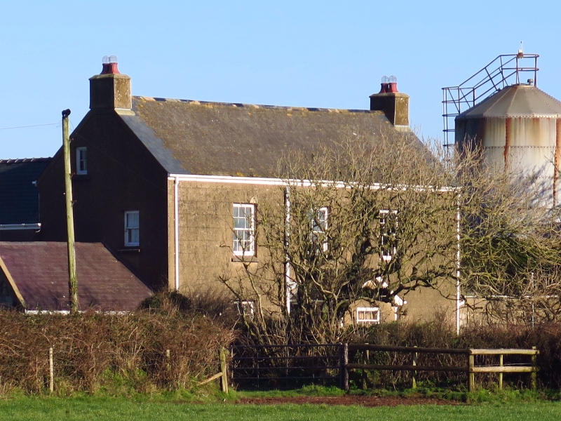
Farmhouse on site of C16 gentry house, the front range probably late C18 or early C19, the rear NW wing possibly much older, the rear NE wing altered in early C20.
Owned by the Paynter family in 1599, described as merchants, later landowners. David Paynter owned the manor of Dale from 1669 to 1699, another David Paynter was High Sheriff in 1743, and the last of the family David Runwa Paynter was owner in 1823, but had moved to Haverfordwest by 1826. Subsequently owned by the Lloyd-Philipps family of Dale Castle.
Farmhouse, unpainted render and roughcast with slate roofs. Later C18 or early C19 front range has 2-storey, 3-window S front, rendered and lined with 12-pane hornless sashes and added rendered gabled porch with S window and E side door. Small rendered end stacks. Small end gable loft windows. W end single-storey outbuilding with grouted slate roof and whitewashed rubble W gable end. Rear has two substantial wings with recessed stair gable between. Stair gable has horned 12-pane sash. NW wing has massive external N end stack with battered sides, possibly C17 or early C18. One W window to first floor over gabled porch with N ledged door. NE wing, probably raised in early C20 has small N stack, paired 4-pane windows to first floor E over door. N end ground floor window.
One of the older historic houses of Dale, still retaining the massive chimney typical of the region.
External links are from the relevant listing authority and, where applicable, Wikidata. Wikidata IDs may be related buildings as well as this specific building. If you want to add or update a link, you will need to do so by editing the Wikidata entry.


Other nearby listed buildings
