Approximate Location Map
Large Map »
Latitude: 51.4919 / 51°29'30"N
Longitude: -3.7239 / 3°43'26"W
OS Eastings: 280414
OS Northings: 178406
OS Grid: SS804784
Mapcode National: GBR H6.K81C
Mapcode Global: VH5HG.DRPN
Plus Code: 9C3RF7RG+QC
Entry Name: The Rest
Listing Date: 17 February 1998
Last Amended: 17 February 1998
Grade: II
Source: Cadw
Source ID: 19365
Building Class: Health and Welfare
ID on this website: 300019365
Location: At the very W end of the town, in a dominating position on the cliff, overlooking the sea and towards the docks and town.
County: Bridgend
Town: Porthcawl
Community: Porthcawl
Community: Porthcawl
Locality: Rest Bay
Traditional County: Glamorgan
Tagged with: Architectural structure
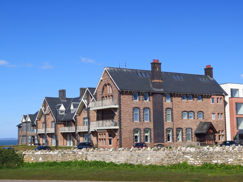
Architect of main building John Prichard 1874; left wing and water tower added 1891- 3 by G F Lambert; rear left wing added in 1900 and right in 1909 by E M Bruce Vaughan. Predecessor of this building was a pair of cottages in New Road Newton acquired by Dr James Lewis, Medical Officer for Bridgend and Cowbridge Union and for Brogden's Mines and Colliery Company as a convalescent home for workers in 1862, a philanthropic enterprise which pre-dated Glamorgan hospitals by 20 years and which developed following a cholera epidemic of 1849. Supported by local landowning families and industrialists and by Florence Nightingale its objects were outlined in Annual Report 1863 ' This is the object of our infant institution, to supply without lowering the independence and self-respect of the individual, yet placing within his reach, the means of perfect and rapid restoration to health, at the very lowest cost, thus affording to the poor those facilities for recovery now only available to the wealthier classes'. Plans for a purpose-built convalescent home began 1869 and the clifftop site was donated by the Talbot family of Margam in 1874, the date of Prichard's plans. Specifically designed to withstand exposed position by projecting buttresses, overhanging eaves; all external walls lined with brick to reduce water penetration; good ventilation and heating (50 fireplaces) in a solid unadorned structure, the cottage style possibly derived from its early history. Originally designed with male and female blocks, only one block could be financed initally; built by Gorvetts of Bristol. Opened in 1877, the first patients being survivors of the Ty Newydd Colliery disaster. 1890s admission registers record variety of occupations of patients who stayed an average of 3 weeks; interdenominational. Funding was via subscription and remained so until 1960s; currently an independent charitable trust. First extension 1891-3 was to provide more accommodation for women, breadwinners having initially been given priority; second extension 1900 was to provide children's wing; third extension 1909 to provide further accommodation including hot and cold sea-water baths. Detached wooden building to rear built 1912 as games room, converted 1952 to centre for paraplegics. Used during both World Wars as an auxiliary hospital. Originally approached from N, new Road across Lock's Common provided entrance from SE 1923. Original accommodation in wards converted to separate rooms from 1970s.
A building on a very large scale which dominates the skyline. Of coursed buff and red rockfaced sandstone with blue and red brick and some ashlar dressings, Welsh slate roof with tall octagonal stacks in groups on ridges. Built in chalet style with added wings on each side. Main central section of 3 storeys comprises two wide 2-bay gabled cross wings with central 2-bay recessed section under deep eaves. The side wings have deep overhanging verges supported each side by triple struts at 45 degree angle; these spring from corbels each side of a central pier rising the full height of the building and increasing in depths through offsets. Overhang provides shelter for a first floor balcony reached through large cambered headed full height windows with replaced glazing; similar to ground floor; above are 2/2 pane square headed casement windows and in the apex slit lights; roof dormers with decorative bargeboards and casement windows on each side; end buttresses also are stepped. Central section has similar windows and balcony. Hipped side wing to right of 2 storeys has cross-frame windows to ground floor and bay with pitched slate roof; bracketed eaves. Behind rises the elaborate water tower ending in a steep hipped roof with metal finials behind a deep embattled parapet with very heavy moulded coping above a bracketed string course.
Attached 3 storey gabled cross wing of 1909 to right has overhanging eaves and tall rectangular chimneys with terracotta pots and overflying courses. Main frontage has large 2nd storey Diocletian style window under moulded brick arch with large keystone; 4-light cross-frame window to first floor and canted bay with 5-light cross frame window to ground floor, all with heavily moulded transoms. Side elevation to right has 3 storeys and 7 assymetrical bays, windows have cambered heads to top two floors and square headed to ground, all with blue brick surrounds; external stack; canted ground floor bay with thick mullions. Main steeply gabled entrance porch of patterned timber and brick has swept eaves, decorative bargeboards and glazing. Rear elevation to Prichard wing is a composition of gables at different heights all with slit apex lights and in front a pointed roofed turret with glazed trefoil headed lights; some original multi-pane casements.
Attached wing of 1900 to rear left facing sea is similar to front right: 2 bays in width and 8 in length, bracketed eaves, Diocletian and multi-pane windows, ground floor cross-frame windows to canted bays, heavy moulded transoms; some original glazing to first floor and ground floor left. Attached 2 storey wing to front left has 2 gabled central bays each with triple cambered headed windows, side bays with hipped roofs with smaller square headed windows under overhanging eaves.
Porch has internal tiling, decorative leading to glazing, terrazzo floor. Corridor parallel to frontage divides front rooms from service rooms and staircases to rear; sited here a Benefactors board 1878-1933 and Florence Nightingale's letter of support. Staircase N has decorative cast iron balusters. Timber ceiling to former kitchen of central section and central timber staircase with sturdy moulded balusters and handrail; pointed arched stone doorways with boarded doors and decorative hinges; some fireplaces to front rooms.
Listed for its unique role in S Wales industrial history, as a specially important welfare building conceived and sustained by local philanthropy and as an example of the work of 3 important S Wales architects; still used for its original function as a convalescent home.
External links are from the relevant listing authority and, where applicable, Wikidata. Wikidata IDs may be related buildings as well as this specific building. If you want to add or update a link, you will need to do so by editing the Wikidata entry.


Other nearby listed buildings
