Approximate Location Map
Large Map »
Latitude: 51.4888 / 51°29'19"N
Longitude: -3.6998 / 3°41'59"W
OS Eastings: 282077
OS Northings: 178015
OS Grid: SS820780
Mapcode National: GBR H7.KG2H
Mapcode Global: VH5HG.TVD3
Plus Code: 9C3RF8Q2+G3
Entry Name: Nottage House
Listing Date: 17 February 1998
Last Amended: 17 February 1998
Grade: II
Source: Cadw
Source ID: 19368
Building Class: Domestic
ID on this website: 300019368
Location: In a prominent position on the hillside just above the main roundabout on the N outskirts of Porthcawl and a little S of Nottage village centre; reached by a short drive.
County: Bridgend
Town: Porthcawl
Community: Porthcawl
Community: Porthcawl
Locality: Nottage
Built-Up Area: Porthcawl
Traditional County: Glamorgan
Tagged with: House
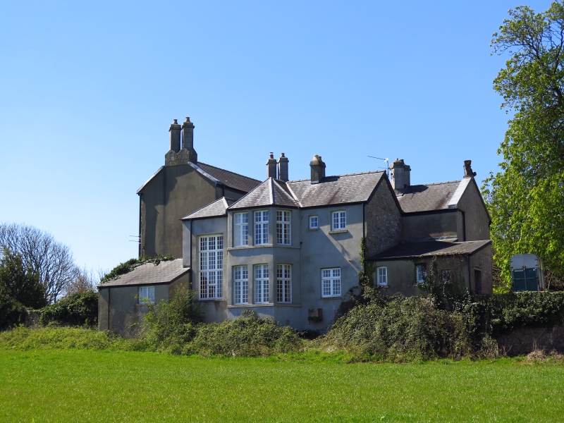
An early - mid C19 house with rear wing partly remodelled late C19 to create an E facing bay and remodelled staircase; shown as L-shaped on Tithe Map of 1846. Reputedly owned by the Superintendent of the Dyffryn Llynfi Porthcawl Railway and recorded as in this company's ownership at time of Tithe Map 1846. Tramroad founded in 1825 originally transported Iron and Coal produced in the Llynfi Valley to Porthcawl Harbour and was in 1860s altered to broad and then standard gauge for the railway to Porthcawl. Original tramway ran very close to E of Nottage Court opposite and immediately W of Nottage House; in 1860s a tunnel was constructed to take the steam railway underneath the village; this, now filled in, is W of the House. An outbuilding to rear reputedly housed the Superintendent's personal horse drawn railway carriage.
Of dressed and coursed limestone with tall angled paired chimneys to main range on deep cross capped plinths; Welsh slate roof with terracotta ridge tiles and rustick stone finial to wing. Plan of 3 storeyed main house with single depth rooms and 2 storeyed double depths cross wing to rear with entrance porch. 3 storeyed main garden front has 2 canted bays to ground floor, flat-arched windows to first floor and 3 to attic close under eaves, all altered glazing. Flat roofed porch to side W has segmental pointed arched doorway, deep voussoirs, bullnosed stone step, vertical panelled door, side window. Four window range to side with voussoirs, sills and altered glazing. Deep single plinth course. Rendered side elevation to E breaks forward from main range with ground floor windows high above ground level of sloping field; two storey canted bay with hipped roof, also to linking staircase bay to left; all multi-pane cross framed windows; lean-to outshut at front and rear single storey outshut. To rear a coach house of rubble with tooled ashlar cambered arched entrance and parallel rubble wing. Rockfaced gatepiers with rustick stone caps and gates to entrance drive.
Interior retains fireplaces, including one wooden with intricate carving of Adam style motifs, 6 panelled doors, panelling to bays, fireplaces recesses, a later C19 open well wooden staircase.
Included as a largely unaltered early- mid C19 house with interesting connections with the Dyffryn Llynfi Porthcawl Tramway.
External links are from the relevant listing authority and, where applicable, Wikidata. Wikidata IDs may be related buildings as well as this specific building. If you want to add or update a link, you will need to do so by editing the Wikidata entry.


Other nearby listed buildings
