Approximate Location Map
Large Map »
Latitude: 53.1074 / 53°6'26"N
Longitude: -3.2056 / 3°12'20"W
OS Eastings: 319385
OS Northings: 357370
OS Grid: SJ193573
Mapcode National: GBR 6X.87SG
Mapcode Global: WH77J.Q5P3
Plus Code: 9C5R4Q4V+XP
Entry Name: Plas yn Pant
Listing Date: 29 May 1998
Last Amended: 29 May 1998
Grade: II
Source: Cadw
Source ID: 19900
Building Class: Domestic
ID on this website: 300019900
Location: Situated on W side of lane to Nant, some 1.3 km N of Llanarmon village.
County: Denbighshire
Town: Ruthin
Community: Llanarmon-yn-Ial (Llanarmon-yn-Iâl)
Community: Llanarmon-yn-Ial
Locality: Llanarmon yn Ial
Traditional County: Denbighshire
Tagged with: Farmhouse
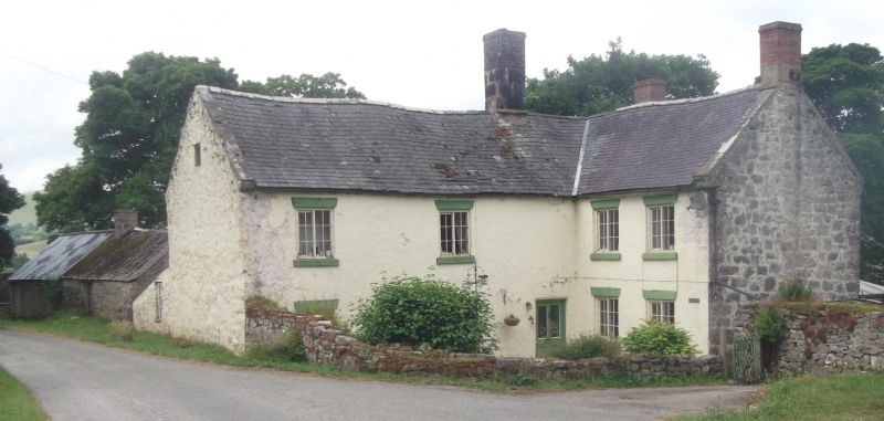
Substantial farmhouse, dated 1726 with initials of M and K Jones and also R and E Jones. In the parish church is a plaque to David Jones d1727, Maurice Jones d1741, Robert Jones d1766 and Cathrine Jones d1753. Marked on 1844 Tithe Map.
Farmhouse, whitewashed roughcast and rubble stone, with slate close-eaved roofs and 3 brick stacks. L-plan. Two storeys and loft, one long range running E-W with large square stone and brick stack on ridge to left of entry and smaller brick W end stack. N front has wing projecting N from right of entry, with N end brick stack. Stone gable coping with moulded stone kneelers. N front has 2-window range of small-paned casement pairs to left of half-glazed door. Windows have heavy painted stone sills and painted heads, possibly slab lintels. N wing has much closer-spaced 2-window range of similar windows facing E and rubble stone windowless N end wall. Main range has whitewashed rubble E gable. S rear wall has big centre projecting gable with date plaque MIK and RIE 1726 to right and first floor left horizontal sliding casement. Lean-to porch with corrugated iron roof to ground floor right. W end gable has 2 windows to ground floor and one horizontal-sliding casement above.
Not accessible at time of survey, position of chimney just to left of entry may indicate a cross-passage behind chimney, but P Smith lists the house as having a lobby-entry plan.
Included as a good example of a C18 large vernacular farmhouse.
External links are from the relevant listing authority and, where applicable, Wikidata. Wikidata IDs may be related buildings as well as this specific building. If you want to add or update a link, you will need to do so by editing the Wikidata entry.


Other nearby listed buildings
