Approximate Location Map
Large Map »
Latitude: 53.3224 / 53°19'20"N
Longitude: -4.6816 / 4°40'53"W
OS Eastings: 221487
OS Northings: 383963
OS Grid: SH214839
Mapcode National: GBR GMTX.N8T
Mapcode Global: WH314.1RXB
Plus Code: 9C5Q88C9+X8
Entry Name: Former powder magazine for fog signalling station and enclosure walls
Listing Date: 30 June 1998
Last Amended: 30 June 1998
Grade: II
Source: Cadw
Source ID: 20076
Building Class: Maritime
ID on this website: 300020076
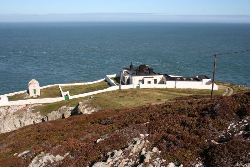
Location: Located on the NE corner of Holy Island, on the edge of high cliffs, in an enclosure bounded by a low stone wall. Reached via a rough track over the headland.
County: Isle of Anglesey
Community: Trearddur
Community: Trearddur
Locality: North Stack
Traditional County: Anglesey
Tagged with: Wall Artillery magazine Magazine (artillery)
Built in 1861 by Trinity House, as a charge store for the the adjacent fog warning cannon. At this time cliff-top cannons were fired throughout the night during foggy weather to warn shipping of coastal dangers. The cannons were made at the Woolwich Arsenal. The building subsequently housed a fog warning klaxon.
A small, single storey building, rectangular in plan, with a narrow, grilled, door to the gable end facing away from the sea. Walls built of coursed rubble; rounded parapets to gable ends, with square step to apex, and quarter-round corbels. Pitched slate roof covering with heavy ridge tiles. The entire building and walls are limewashed. Over the door is the Trinity House coat of arms with '1861' inscribed above and 'MAGAZINE' below. The building is within an enclosure defined by low white-washed rubble walls.
Listed as a good, well-preserved example of one of the specialised building types developed by Trinity House in association with coastal navigation, and of local historical interest as part of the warning system guiding coastal traffic associated with the port of Holyhead, a major port in the C19.
External links are from the relevant listing authority and, where applicable, Wikidata. Wikidata IDs may be related buildings as well as this specific building. If you want to add or update a link, you will need to do so by editing the Wikidata entry.


Other nearby listed buildings
