Approximate Location Map
Large Map »
Latitude: 51.9254 / 51°55'31"N
Longitude: -3.2921 / 3°17'31"W
OS Eastings: 311241
OS Northings: 225999
OS Grid: SO112259
Mapcode National: GBR YT.NVBW
Mapcode Global: VH6C0.WVFV
Plus Code: 9C3RWPG5+54
Entry Name: Pennorth railway bridge
Listing Date: 21 August 1998
Last Amended: 21 August 1998
Grade: II
Source: Cadw
Source ID: 20336
Building Class: Transport
ID on this website: 300020336
Location: In the hamlet of Pennorth adjacent to the crossroads.
County: Powys
Community: Llangors (Llan-gors)
Community: Llangors
Locality: Pennorth
Traditional County: Brecknockshire
Tagged with: Road bridge
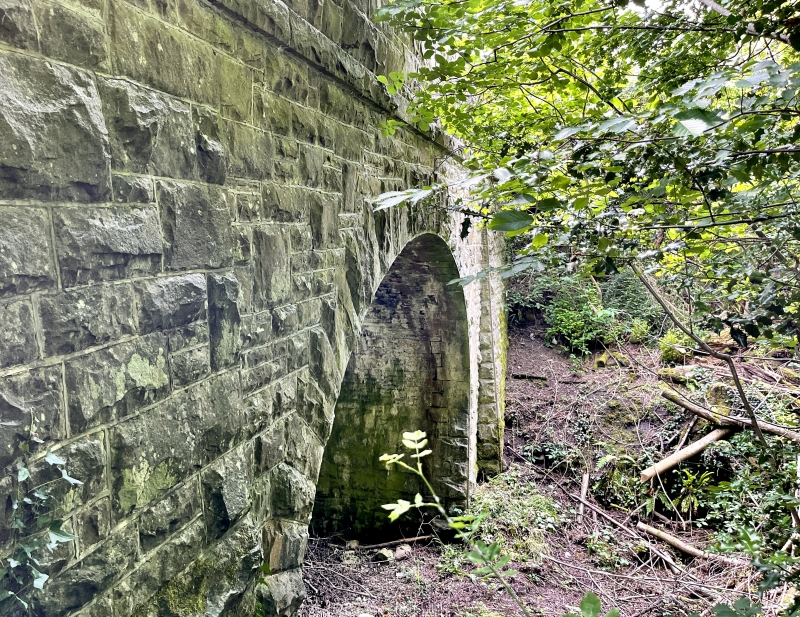
Built in 1860s, part of the Brecon and Merthyr Railway. The line of the Hay Railway between Hay on Wye and Brecon, built 1816-1818 mainly to transport coal and iron from the Brecknock and Abergavenny Canal at Brecon northwards into Herefordshire, ran a short distance to N at Tal-y-llyn. This was later adapted for the Brecon and Merthyr Railway built 1860s which turned S at Tal-y-llyn Junction, crossed the canal at Talybont, then climbing up - a rise of 925 ft (282m) including 6 1/2 miles (10.5km) at 1 in 38 - and tunnelling through the mountains at Torpantau tunnel, terminated at Merthyr. It was sponsored by Brecon bankers and local interests including the de Winton family, Brecon industrialists. First 19 miles from Brecon to Pant opened 1863, extended to Dowlais 1869 and thence to Merthyr, engineer Henry Conybeare. The hamlet of Pennorth appears to have developed around the railway with nearby houses dated 1860s. Line closed 1960s.
High bridge carrying the road S of Llangorse Lake over the deep railway cutting. Built of snecked rockfaced sandstone. Arch has diamond shaped voussoirs and smooth narrow arises; similar arises to the abutments which project either side; stringcourse at parapet level mostly masked by vegetation. Coping of giant rockfaced blocks.
Included as a surviving intact bridge associated with the Brecon and Merthyr Railway.
External links are from the relevant listing authority and, where applicable, Wikidata. Wikidata IDs may be related buildings as well as this specific building. If you want to add or update a link, you will need to do so by editing the Wikidata entry.


Other nearby listed buildings
