Approximate Location Map
Large Map »
Latitude: 53.066 / 53°3'57"N
Longitude: -4.0114 / 4°0'41"W
OS Eastings: 265320
OS Northings: 353972
OS Grid: SH653539
Mapcode National: GBR 5V.BXQG
Mapcode Global: WH552.C61D
Plus Code: 9C5Q3X8Q+9C
Entry Name: Cwm Dyli Power Station
Listing Date: 25 November 1998
Last Amended: 25 November 1998
Grade: II*
Source: Cadw
Source ID: 20926
Building Class: Industrial
Also known as: Cwm Dyli Power Station
ID on this website: 300020926
Location: Located towards the northern boundary of the community in an isolated site on the E side of the Afon Cynnyd, at the end of the Glaslyn valley; accessed via a long track continuing on from the old vall
County: Gwynedd
Town: Porthmadog
Community: Beddgelert
Community: Beddgelert
Locality: Afon Glaslyn
Traditional County: Caernarfonshire
Tagged with: Power station Hydroelectric power station
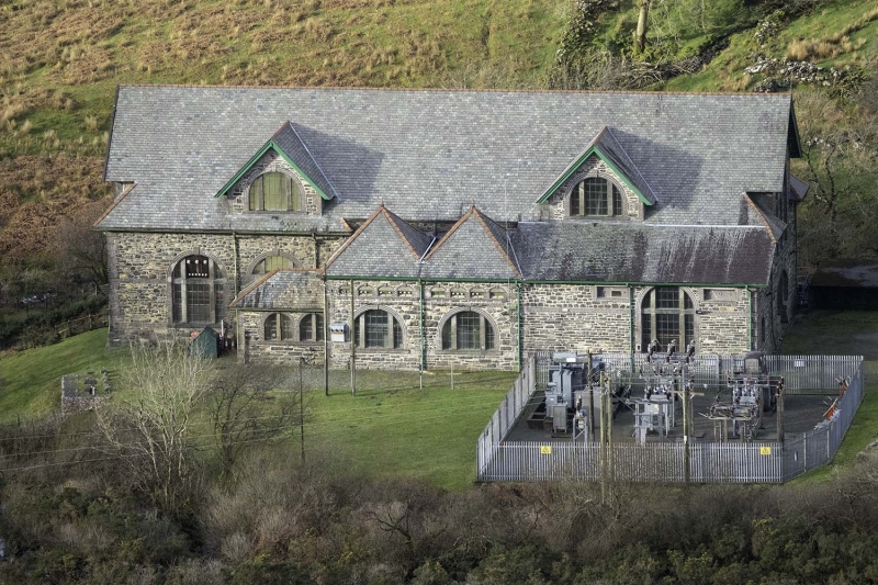
Hydro-electric power station built in 1906 and pioneering as the first instance in Britain of the use of Alternating Current. The power station was built by the North Wales Power and Traction Co, and was conceived to serve the Oakley, Dinorwic and Pen-yr-Orsedd quarries. The company had been established in 1904 by Platt and Tomkinson; the electrical engineers Bruce Peebles of Edinburgh received the contract for the turbines with Harpur Bros. as consulting Engineers. Current was derived from harnessing the water from Llyn Llydaw and energy was transmitted at 10,000 volts. The power station was much lauded in its day as a 'triumph of modern transmission' and with its bold basilica-like design soon became known locally as 'the chapel in the valley'.
Large rectangular hydro-electric turbine house conceived in a bold alpine arts-and crafts style, appropriate to its mountainous setting. Of quarry-dressed limestone construction on a slightly-battered base and with brown brick and tooled limestone dressings. Renewed slate roofs with tiled ridges and oversailing eaves; plain bargeboards with deep verges. The building is of one tall storey with a large pitched roof hipped at the narrow ends to either side of a large central gable; these gables accommodate tall round-arched windows, the upper sections of which break the eaves. The long sides are of 7 bays and these and the ends both have broad lacing courses of brick with rusticated brick quoins at the corners. The side windows are smaller versions of those at the ends; all have brick voussoirs, with projecting brick sills and keys. Limestone mullions and transomes producing Diocletian effect; obscured small-pane glazing.
The E side has a 2-bay central projection with paired, hipped roofs. These have actual Diocletian windows, one to each bay, each with 4 blind brick segmental niches above. Extruded in the angle between this projection and the main block on the S side is a low primary infill section with hipped roof and paired arched windows. A similar arrangement originally existed on the N side, though a more recent flush continuation of the projection has superseded this; this alteration has carefully copied the style of the primary work and has reused original dressings to match.
The (N) entrance front has a wide segmental arch below its large window, within which is a central entrance and flanking lights; boarded doors. The modern alteration to the E side is flush with this facade and has an arched window with oculus diagonally above.
The interior was not accessible at the time of survey.
Listed Grade II* for its special interest as an early C20 power station of considerable architectural confidence and quality, and for its pioneering role in the history of British hydro-electric power.
External links are from the relevant listing authority and, where applicable, Wikidata. Wikidata IDs may be related buildings as well as this specific building. If you want to add or update a link, you will need to do so by editing the Wikidata entry.


Other nearby listed buildings
