Approximate Location Map
Large Map »
Latitude: 51.6279 / 51°37'40"N
Longitude: -3.1291 / 3°7'44"W
OS Eastings: 321940
OS Northings: 192728
OS Grid: ST219927
Mapcode National: GBR J0.8MM1
Mapcode Global: VH6DN.QB4W
Plus Code: 9C3RJVHC+59
Entry Name: Former Railway bridge over canal outfall
Listing Date: 23 December 1998
Last Amended: 23 December 1998
Grade: II
Source: Cadw
Source ID: 21009
Building Class: Transport
ID on this website: 300021009
Location: In the centre of Pont-y-Waun near the Philanthropic Inn, adjacent to the canal on the W side and N of the former Pont-y-Waun farm in the meadow below.
County: Caerphilly
Community: Crosskeys
Community: Crosskeys
Locality: Pont-y-Waun
Built-Up Area: Risca
Traditional County: Monmouthshire
Tagged with: Railway bridge
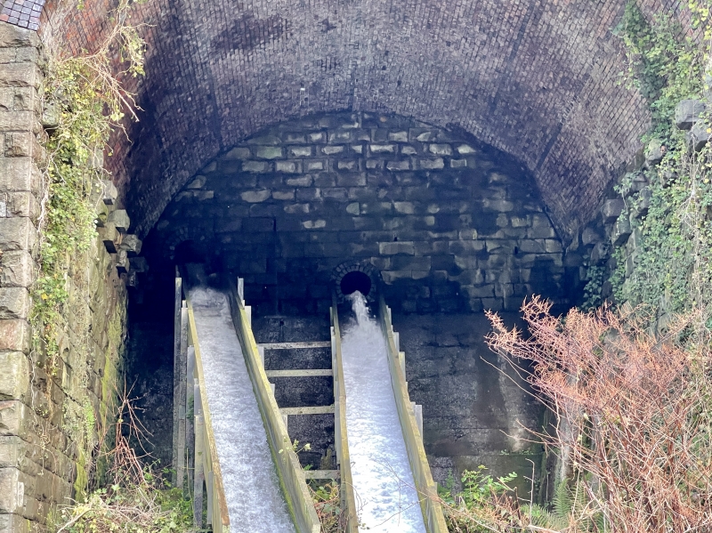
Canal outfall and railway shows on OS maps, both First Edition 1886 surveyed 1873-9 and Second Edition 1902. The railway is shown as a tramway on the First Edition map and appears to have been remodelled by the time of the Second Edition map as the Great Western Region Pennar Branch, joining with the 1850s Western Valley Line further S. Nearby viaduct remodelled c 1900 shares the same line.
A high arch carrying the railway over the canal outfall. Almost entirely masked by vegetation, the bridge is of giant rockfaced coursed stone blocks with dressed arises, buttressed to N. The canal sluice is on the E side and a culvert channels the water under the canal, exiting through the brick-vaulted round-headed arch as a waterfall. Low parapet has blue moulded brick coping with a projecting tooled course at base level on the outer face.
Listed as a prominent railway structure from the later C19 on a huge scale and with historical associations with the canal. Group value with nearby Viaduct.
External links are from the relevant listing authority and, where applicable, Wikidata. Wikidata IDs may be related buildings as well as this specific building. If you want to add or update a link, you will need to do so by editing the Wikidata entry.


Other nearby listed buildings
