Latitude: 51.8441 / 51°50'38"N
Longitude: -3.3606 / 3°21'38"W
OS Eastings: 306365
OS Northings: 217046
OS Grid: SO063170
Mapcode National: GBR YQ.V313
Mapcode Global: VH6CC.PXR5
Plus Code: 9C3RRJVQ+MQ
Entry Name: Pont Blaen-y-glyn
Listing Date: 17 December 1998
Last Amended: 17 December 1998
Grade: II
Source: Cadw
Source ID: 21133
Building Class: Transport
ID on this website: 300021133
Location: At the W end of Glyn Collwn and the Talybont reservoir, the mountain road crossing Afon Caerfanell just before it rises to climb the pass to Pontsticill.
County: Powys
Community: Talybont-on-Usk (Tal-y-bont ar Wysg)
Community: Talybont-on-Usk
Locality: Glyn Collwn
Traditional County: Brecknockshire
Tagged with: Bridge Road bridge
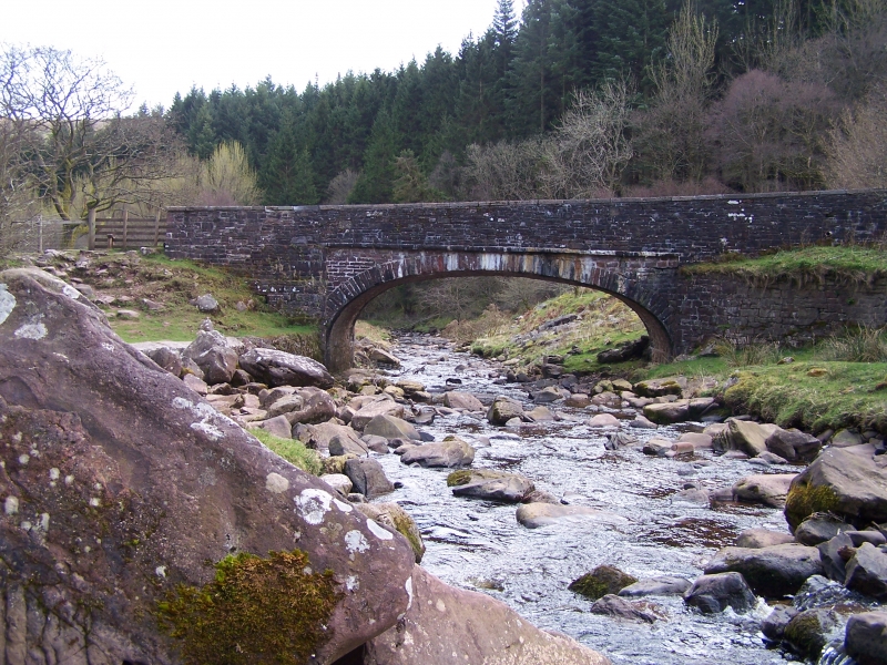
Probably C19 and one of a number of bridges of similar date S of Talybont, probably part of road improvements resulting from the canal trade and the need to link this with the industry and materials to south; this stretch of the Monmouthshire and Brecon Canal between Talybont and Brecon opened 1800.
Bridge of stone rubble over a mountain river. Wide basket arch spans the river; the arch has very narrow voussoirs and is slightly recessed; the parapet coping replaced with concrete; partly tiered abutments.
Listed as a fine early C19 mountain river bridge.
External links are from the relevant listing authority and, where applicable, Wikidata. Wikidata IDs may be related buildings as well as this specific building. If you want to add or update a link, you will need to do so by editing the Wikidata entry.


Other nearby listed buildings