History in Structure

Churchyard Cross, Church of St Bridget

A Grade II Listed Building in St Brides Major, Vale of Glamorgan

More Photos »
Approximate Location Map
Large Map »

Coordinates

Latitude: 51.4633 / 51°27'47"N

Longitude: -3.593 / 3°35'34"W

OS Eastings: 289431

OS Northings: 175014

OS Grid: SS894750

Mapcode National: GBR HC.M4XS

Mapcode Global: VH5HQ.NHW3

Plus Code: 9C3RFC74+8Q

Entry Name: Churchyard Cross, Church of St Bridget

Listing Date: 3 March 1999

Last Amended: 3 March 1999

Grade: II

Source: Cadw

Source ID: 21767

Building Class: Religious, Ritual and Funerary

Also known as: St Bride's Major Churchyard Cross

ID on this website: 300021767

Location: Located on the N side of the Church of St. Bridget, to the E of the porch. The platform is built into the hillside which slopes down to the N.

County: Vale of Glamorgan

Community: St. Bride's Major (Saint-y-Brid)

Community: St. Bride's Major

Locality: St Brides Major

Built-Up Area: St Brides Major

Traditional County: Glamorgan

Tagged with: Cross Churchyard cross

Find accommodation in
Saint Brides Major

History

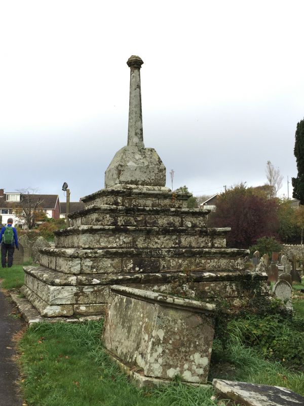
C16 preaching cross. Pilgrims knelt in prayer on the stone steps, and farm workers are said to have sharpened their sickles on them. Said to have been damaged during Cromwell’s time. Restored in 1985.

Exterior

Stone churchyard cross on large 6-step platform. Heavy flagstone caps to steps with moulded edges. The base of the cross is square with deeply chamfered top angles. Polygonal tapering shaft with broach stops, surmounted by an orb with mouldings and small foliate bosses to underside.

Reasons for Listing

An exceptionally well preserved example of a medieval preaching cross. Group value with the church.

Scheduled Ancient Monument Gm 174.

External Links

External links are from the relevant listing authority and, where applicable, Wikidata. Wikidata IDs may be related buildings as well as this specific building. If you want to add or update a link, you will need to do so by editing the Wikidata entry.

Recommended Books

Other nearby listed buildings

  • II* Church of St Bridget
    Set within a polygonal churchyard on the hillside, towards the NW end of St. Brides Major.
  • II Bryn Sion Presbyterian Chapel
    Located on the E side of Pen-y-lan Road on the hillside above the village centre. The chapel is cut into the hillside within its own enclosure of rubble stone walls surmounted by iron railings.
  • II The Old Vicarage
    Located on the S side of the main road which links St. Brides Major with Pitcot, to the W of the junction with the road which leads to Southerndown. The rear garden has a ha-ha.
  • II Pen Ucha Dre
    Located at the E end of Pitcot, on the N side of the road leading out of St. Brides Major to Wick. Associated farm buildings are to the N of the house.
  • II Barn & Cow-houses at Pen Ucha Dre
    Located to the N of Pen Ucha Dre Farmhouse.
  • II Evergreen Cottage
    Fronting the S side of the common at Heol y Mynydd, on a narrow lane leading from St. Brides Major.
  • II Bee Boles at Blackhall Farm
    Located on the N side of a lane which runs from St. Brides Major to Castle-upon-Alun, adjoining Blackhall farmhouse.
  • II Blackhall Farm
    Located on the N side of a lane which runs from St. Brides Major to Castle-upon-Alun. In a slightly raised position, cut into the hillside, with the front facing downslope.

BritishListedBuildings.co.uk is an independent online resource and is not associated with any government department. All government data published here is used under licence. Please do not contact BritishListedBuildings.co.uk for any queries related to any individual listed building, planning permission related to listed buildings or the listing process itself.

British Listed Buildings is a Good Stuff website.