History in Structure

Pont Penllyn (partly in Llanddeiniolen community)

A Grade II Listed Building in Llanberis, Gwynedd

More Photos »
Approximate Location Map
Large Map »

Coordinates

Latitude: 53.1386 / 53°8'19"N

Longitude: -4.155 / 4°9'17"W

OS Eastings: 255943

OS Northings: 362334

OS Grid: SH559623

Mapcode National: GBR 5N.6C4W

Mapcode Global: WH54M.4CPP

Plus Code: 9C5Q4RQW+F2

Entry Name: Pont Penllyn (partly in Llanddeiniolen community)

Listing Date: 28 May 1999

Last Amended: 28 May 1999

Grade: II

Source: Cadw

Source ID: 21856

Building Class: Transport

Also known as: Pont Penllyn (partly in Llanberis Community)

ID on this website: 300021856

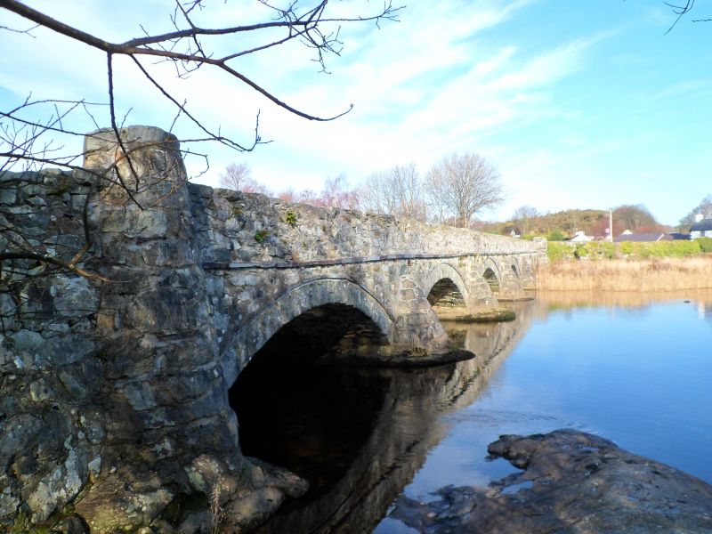
Location: Located at the north-western end of Llyn Padarn at the point where it is fed by the Afon Rythallt; the lake and river form the community boundary between Llanberis and Llanddeiniolen.

County: Gwynedd

Community: Llanberis

Community: Llanberis

Locality: Pen-y-llyn

Traditional County: Caernarfonshire

Tagged with: Bridge Road bridge

Find accommodation in
Cwm-y-glo

History

Shown on the 1838 Tithe Map, the bridge appears to have been built in the early C19 as part of the general road and transport improvements carried out in the Llanberis area during this period.

Exterior

Bridge. Irregularly coursed and dressed rubblestone with simple coping, slate-slab string course, arch-rings and voussoirs to 4 segmental arches; cutwaters on east side and tapering circular piers to corners.

Reasons for Listing

Included as a substantial and largely unaltered early C19 bridge of strong vernacular character.

External Links

External links are from the relevant listing authority and, where applicable, Wikidata. Wikidata IDs may be related buildings as well as this specific building. If you want to add or update a link, you will need to do so by editing the Wikidata entry.

Recommended Books

Other nearby listed buildings

  • II Pont Penllyn (partly in Llanberis Community)
    Located at the north-western end of Llyn Padarn at the point where it is fed by the Afon Rythallt; the lake and river form the community boundary between Llanberis and Llanddeiniolen.
  • II Farmbuildings and screen wall at Llwyn Coed
    Situated in their own yard a little to the north-west of the farmhouse at Llwyn Coed.
  • II Llwyn Coed
    Situated at the end of a farm track off the A 4086 in level fields with wooded rising ground behind.
  • II Pen y Clogwyn
    Situated in remote upland position in rocky landscape with small fields divided by drystone walls.
  • II Pant-y-Celyn
    Located on the east side of the main village street at Cwm-y-glo towards its northern end; low rubblestone wall in front with stone-on-edge coping and decorated iron gate aligned on front door.
  • II Pen-y-Clip
    Situated at western end of Fachwen on wooded slope immediately by the side of the Brynrefail to Dinorwic Road on the north side of Llyn Padarn; there is a large rock outcrop immediately behind the cot
  • II Pen Rallt
    Located at the end of a track running downslope from the minor road between Cwm-y-glo and Bryn Bras Castle.
  • II Bron Ceris
    Set just below the road running through Fachwen from Brynrefail to Dinorwic above the north side of Llyn Padarn.

BritishListedBuildings.co.uk is an independent online resource and is not associated with any government department. All government data published here is used under licence. Please do not contact BritishListedBuildings.co.uk for any queries related to any individual listed building, planning permission related to listed buildings or the listing process itself.

British Listed Buildings is a Good Stuff website.