Latitude: 53.1034 / 53°6'12"N
Longitude: -3.3746 / 3°22'28"W
OS Eastings: 308066
OS Northings: 357133
OS Grid: SJ080571
Mapcode National: GBR 6P.8GRP
Mapcode Global: WH77G.4895
Plus Code: 9C5R4J3G+95
Entry Name: Timber-framed Agricultural Building at Pistyll-Gwyn
Listing Date: 17 June 1999
Last Amended: 17 June 1999
Grade: II
Source: Cadw
Source ID: 21874
Building Class: Agriculture and Subsistence
ID on this website: 300021874
Location: Located towards the eastern boundary of the community, approximately 0.5km SW of Bont-uchel; sited within the farmyard on a slight rise to the N of a lane running SW from Bont-Uchel; adjoining a range
County: Denbighshire
Town: Ruthin
Community: Cyffylliog
Community: Cyffylliog
Locality: Bont-uchel
Traditional County: Denbighshire
Tagged with: Architectural structure
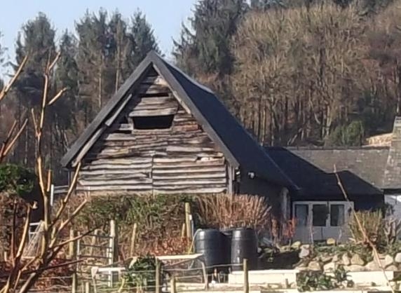
Late C16 or early C17 two-bay box-framed agricultural building, probably originally a barn, with later (perhaps C18) weather-boarding surviving in part. A single bay rubble extension was added to the rear, probably in the C18; both sections were given corrugated iron roofs (and, in part, sides), earlier this century.
Two-bay box-framed agricultural building with further, additional rubble bay adjoining to the W. The primary section has (original) rubble lower walls to the N and S sides, as well as to the W gable end. The former rise to a height of approximately 1m, the gable wall rising to wall-plate height; above this the timber-framed construction survives 95% complete, though it is externally clad in corrugated iron, as is the roof. The E gable is fully timber framed and retains old horizontal weather-boarding (applied externally) to much of its surface; some similar weather-boarding survives to the S wall of the western bay, beneath the corrugated iron sheeting. Entrances to the N (farmyard) side at L, and to the S in the centre, the former retaining the top section of an old boarded stable door, the latter boarded shut. The rubble additional bay has a slightly shallower roof pitch and has an entrance to the L (facing the farmyard) with pegged oak frame and boarded stable door.
Beaten earth floor to primary section, with central truss of tie-beam and raking-strut type, the tie-beam showing evidence of having formerly had a partition below; queen post truss to rear gable (dividing primary from additional section). Prominent construction marks to framing.
Listed for its special interest as a scarce regional example of a late C16 or early C17 timber-framed barn.
External links are from the relevant listing authority and, where applicable, Wikidata. Wikidata IDs may be related buildings as well as this specific building. If you want to add or update a link, you will need to do so by editing the Wikidata entry.


Other nearby listed buildings