History in Structure

Lychgate at St Tudor's Church Mynyddislwyn

A Grade II Listed Building in Ynysddu, Caerphilly

More Photos »
Approximate Location Map
Large Map »

Coordinates

Latitude: 51.6386 / 51°38'19"N

Longitude: -3.1668 / 3°10'0"W

OS Eastings: 319350

OS Northings: 193960

OS Grid: ST193939

Mapcode National: GBR HY.7XVY

Mapcode Global: VH6DN.226N

Plus Code: 9C3RJRQM+F7

Entry Name: Lychgate at St Tudor's Church Mynyddislwyn

Listing Date: 16 September 1999

Last Amended: 16 September 1999

Grade: II

Source: Cadw

Source ID: 22315

Building Class: Religious, Ritual and Funerary

ID on this website: 300022315

Location: On the N side of the churchyard adjacent to the Church Inn, forming the main entrance to the walled churchyard.

County: Caerphilly

Community: Ynysddu (Ynys-ddu)

Community: Ynysddu

Locality: Mynyddislwyn

Traditional County: Monmouthshire

Tagged with: Lychgate

Find accommodation in
Mynyddislwyn

History

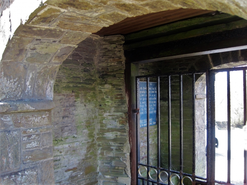
Probably contemporary with the rebuilding work on the church c 1820.

Exterior

Lychgate is a symmetrical almost square building of tooled stone and coursed rubble with a pyramidal tiled roof and overhanging eaves; eilliptical archways with voussoirs and a string course at impost level; iron gates with roundel motif. Service board attached to front.

Interior

Stone benches are on either side of the wall.

Reasons for Listing

An unusually well-designed lychgate which has group value with the church.

External Links

External links are from the relevant listing authority and, where applicable, Wikidata. Wikidata IDs may be related buildings as well as this specific building. If you want to add or update a link, you will need to do so by editing the Wikidata entry.

Recommended Books

Other nearby listed buildings

  • II* Church of St Tudor Mynyddislwyn
    On the crest of Mynyddislwyn, surrounded by a walled churchyard.
  • II Caerllwyn Isaf and attached byre/stable
    On the W flank of Mynyddislwyn, close to the N/S mountain road which leads S to Cwmfelinfach in the Sirhowy Valley; stands in a walled and gated enclosure with stone stile to field.
  • II Ton-eithin
    Just E of the crest of Mynyddislwyn, SE of the church, on the upper slope of Nant Hafod-Tudur, reached by a long farm track.
  • II Glebe Farm
    On the S flank of Mynyddislwyn, off the E side of the lane leading S to Cwmfelin-fach, and reached by a farm track across fields.
  • II Wall, railings and gates at New Bethel Chapel graveyard
    Wall completely surrounds the original graveyard and extends uphill along the lane fronting the graveyard extension, ending in a recess with double gates.
  • II Ty Mynydd
    On the mountain W of Abercarn, NE of the mountain hamlet of Mynyddislwyn and reached by a track from the Craig y Darren lane.
  • II Monuments to James Thomas and family at New Bethel
    In New Bethel graveyard, on the S side of the chapel, the figure monument on the boundary wall between the old cemetery and the extension with the tomb chest below.
  • II Monument to Thomas Henry Thomas at New Bethel
    On the S side of the chapel, a little N of the James Thomas monument and also by the wall dividing the original cemetery from the later extension.

BritishListedBuildings.co.uk is an independent online resource and is not associated with any government department. All government data published here is used under licence. Please do not contact BritishListedBuildings.co.uk for any queries related to any individual listed building, planning permission related to listed buildings or the listing process itself.

British Listed Buildings is a Good Stuff website.